1960s Maps of Busby, Busby District
Explore 2 historic maps of Busby from the 1960s. These maps offer a rare glimpse into what life looked like during the 1960s — showing old roads, neighborhoods, homes, and landmarks that have changed or disappeared over time.
Whether you're researching your family's past, planning a metal detecting trip, or studying how Busby's landscape evolved across the 1960s, these high-resolution maps are a powerful tool for exploring the history of this region.
- Focus on a specific era: All maps on this page are from the 1960s, giving you a focused view of this time period.
- See what’s changed: Compare century-old streets, trails, and buildings to today's modern landscape using overlays and satellite layers.
- Research with precision: Use these maps for genealogy, historical research, land use analysis, or educational projects.
- View, download, or print: Maps are fully viewable online in high resolution, and can be downloaded or printed for your own records.
Start exploring Busby's history through authentic maps from the 1960s. This is your window into the past.
Busby, Busby District maps
(2)- 1967 Map of Jeans Fork SE, 1971 Print
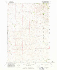 1967 Jeans Fork SE1971 Print · USGSBig Horn County, Montana, is shown here in the late 1960s as a landscape of isolated water sources and reservation borders. Researchers can trace family-named water features and early aviation markers like the Landing Strip and the Northern Cheyenne Indian Reservation Boundary.
 - 1967 Map of Thompson Creek, 1971 Print
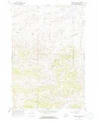 1967 Thompson Creek1971 Print · USGSBig Horn County ranchlands and tribal territories are captured here in the late sixties, showing a landscape defined by water and isolation. Researchers can trace the boundary of the Northern Cheyenne Indian Reservation and locate remote sites like Spear Ranch and the local Landing Strip.2 unique versions available
End of results
Showing maps 1-2 of 2
Top cities near Busby
Top neighborhoods of Busby
Frequently asked questions
- What are the different types of historical maps available for Busby?
- What is the oldest map of Busby?
- Where can I purchase historical maps of Busby for my home or office?
- Where can I download high-res historical maps of Busby?
- Are there historical topographic maps available for Busby?
- Is there historical aerial imagery available for Busby?
- Where are historical maps of Busby sourced from?