1970s Maps of Hays, Hays District
Explore 4 historic maps of Hays from the 1970s. These maps offer a rare glimpse into what life looked like during the 1970s — showing old roads, neighborhoods, homes, and landmarks that have changed or disappeared over time.
Whether you're researching your family's past, planning a metal detecting trip, or studying how Hays's landscape evolved across the 1970s, these high-resolution maps are a powerful tool for exploring the history of this region.
- Focus on a specific era: All maps on this page are from the 1970s, giving you a focused view of this time period.
- See what’s changed: Compare century-old streets, trails, and buildings to today's modern landscape using overlays and satellite layers.
- Research with precision: Use these maps for genealogy, historical research, land use analysis, or educational projects.
- View, download, or print: Maps are fully viewable online in high resolution, and can be downloaded or printed for your own records.
Start exploring Hays's history through authentic maps from the 1970s. This is your window into the past.
Hays, Hays District maps
(4)- 1971 Map of Hays, 1974 Print
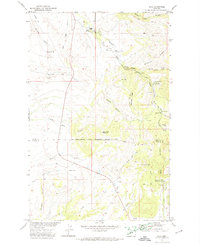 1971 Hays1974 Print · USGSThe Fort Belknap Indian Reservation comes into focus during the 1970s, centered on the community of Hays. Researchers can trace the grounds of St Pauls Mission, locate family sites at Laddusky Cem, or explore the foothills near Eagle Child Mountain.
 - 1971 Map of Stiffarm Coulee, 1974 Print
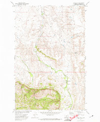
 1971 Stiffarm Coulee1974 Print · USGSThe southern portion of the Fort Belknap Indian Reservation is shown here in the early 1970s as the plains meet the Little Rocky Mountains. Researchers can trace remote landmarks like a lone Grave and family-named features including Four Bear Coulee and Powder Face Canyon.
 - 1971 Map of Lodge Pole, 1974 Print
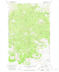
 1971 Lodge Pole1974 Print · USGSThe Fort Belknap Indian Reservation is documented here in the early 1970s as it meets the northern foothills of the Little Rockies. Local researchers can trace family landmarks and water sources like Lodge Pole, Black Bull Spring, and Mouse Butte.
 - 1971 Map of Zortman, 1974 Print
 1971 Zortman1974 Print · USGSThe Little Rocky Mountains of Montana are captured in the early 1970s, showcasing a landscape shaped by persistent mining and high-elevation terrain. Researchers can trace the layout of mining camps like Zortman and Landusky alongside shafts such as the Little Ben Mine and Gold Bug Mine.
End of results
Showing maps 1-4 of 4
Top neighborhoods of Hays
Frequently asked questions
- What are the different types of historical maps available for Hays?
- What is the oldest map of Hays?
- Where can I purchase historical maps of Hays for my home or office?
- Where can I download high-res historical maps of Hays?
- Are there historical topographic maps available for Hays?
- Is there historical aerial imagery available for Hays?
- Where are historical maps of Hays sourced from?