1900s (20th Century) Maps of Hays, Hays District
Explore 12 historic maps of Hays from the 1900s (20th Century). These maps offer a rare glimpse into what life looked like during the 1900s — showing old roads, neighborhoods, homes, and landmarks that have changed or disappeared over time.
Whether you're researching your family's past, planning a metal detecting trip, or studying how Hays's landscape evolved across the 1900s, these high-resolution maps are a powerful tool for exploring the history of this region.
- Focus on a specific era: All maps on this page are from the 1900s, giving you a focused view of this time period.
- See what’s changed: Compare century-old streets, trails, and buildings to today's modern landscape using overlays and satellite layers.
- Research with precision: Use these maps for genealogy, historical research, land use analysis, or educational projects.
- View, download, or print: Maps are fully viewable online in high resolution, and can be downloaded or printed for your own records.
Start exploring Hays's history through authentic maps from the 1900s. This is your window into the past.
Hays, Hays District maps
(12)- 1943 Map of Landusky
 1943 Landusky1943 Print · USGSPhillips County during the early 1940s is shown here as a landscape of isolated mountain settlements and the wild Missouri Breaks. Researchers can trace the layout of Landusky, the mountain peaks of the Jefferson National Forest, and river landmarks such as Cow Island.
 - 1953 Map of Havre, 1967 Print
 1953 Havre1967 Print · USGSNorthern Montana’s Hi-Line comes into focus in the mid-fifties, centered on the Milk River and the critical Great Northern rail link. Genealogists can trace small sidings and settlements like Assinniboine, Laredo, and Box Elder alongside the Fort Belknap Agency.3 unique versions available
 - 1954 Map of Lewistown, 1967 Print
 1954 Lewistown1967 Print · USGSCentral Montana at the height of the mid-century rail era reveals a landscape shaped by the Judith River and high mountain ranges. Trace the old lines of the Great Northern through Lewistown and Denton, or locate sites like Giltedge and Landusky.3 unique versions available
 - 1957 Map of Havre
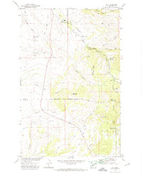
 1957 Havre1957 Print · USGSNorth-central Montana at the mid-century is defined by the vital Great Northern rail corridor and the winding Milk River. Researchers can trace old settlements like Laredo and Savoy, or locate historic sites such as the Hays (old) Sub Agency and the Chinook No 1 mine.
 - 1958 Map of Havre
 1958 Havre1958 Print · USGSUpper Montana in the late fifties was a landscape of remote rail towns and vast high-plain ranges. Genealogists and historians can trace the Great Northern railroad through Havre, Chinook, and the Fort Belknap Indian Reservation.
 - 1959 Map of Lewistown
 1959 Lewistown1959 Print · USGSCentral Montana in the mid-1950s shows a landscape defined by the winding Missouri River and the rise of the South Moccasin Mtns. Researchers can trace the rail lines of the Great Northern through towns like Winifred and locate the Cat Creek Oil Field.3 unique versions available
 - 1971 Map of Hays, 1974 Print
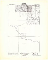
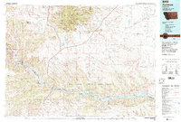
 1971 Hays1974 Print · USGSThe Fort Belknap Indian Reservation comes into focus during the 1970s, centered on the community of Hays. Researchers can trace the grounds of St Pauls Mission, locate family sites at Laddusky Cem, or explore the foothills near Eagle Child Mountain.
 - 1971 Map of Stiffarm Coulee, 1974 Print
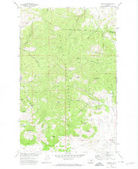
 1971 Stiffarm Coulee1974 Print · USGSThe southern portion of the Fort Belknap Indian Reservation is shown here in the early 1970s as the plains meet the Little Rocky Mountains. Researchers can trace remote landmarks like a lone Grave and family-named features including Four Bear Coulee and Powder Face Canyon.
 - 1971 Map of Lodge Pole, 1974 Print
 1971 Lodge Pole1974 Print · USGSThe Fort Belknap Indian Reservation is documented here in the early 1970s as it meets the northern foothills of the Little Rockies. Local researchers can trace family landmarks and water sources like Lodge Pole, Black Bull Spring, and Mouse Butte.
 - 1971 Map of Zortman, 1974 Print
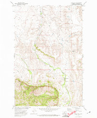
 1971 Zortman1974 Print · USGSThe Little Rocky Mountains of Montana are captured in the early 1970s, showcasing a landscape shaped by persistent mining and high-elevation terrain. Researchers can trace the layout of mining camps like Zortman and Landusky alongside shafts such as the Little Ben Mine and Gold Bug Mine.
 - 1984 Map of Zortman
 1984 Zortman1984 Print · USGSCentral Montana in the mid-eighties shows a vast landscape of tribal lands and protected wilderness along the Missouri River breaks. Genealogists and historians can trace the remote settlements of Zortman and Landusky or locate landmarks like Mission Peak and D V Junction.
 - 1984 Map of Dodson, 1985 Print
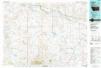 1984 Dodson1985 Print · USGSNorthern Montana ranching and reservation life are captured here in the mid-eighties as the Milk River valley sustains a string of railroad towns. Researchers can locate historic sites like Graveyard Hill, the Fort Belknap Agency, and several rural schoolhouses.
End of results
Showing maps 1-12 of 12
Top neighborhoods of Hays
Frequently asked questions
- What are the different types of historical maps available for Hays?
- What is the oldest map of Hays?
- Where can I purchase historical maps of Hays for my home or office?
- Where can I download high-res historical maps of Hays?
- Are there historical topographic maps available for Hays?
- Is there historical aerial imagery available for Hays?
- Where are historical maps of Hays sourced from?