1980s Maps of Boyes, Montana
Explore 2 historic maps of Boyes from the 1980s. These maps offer a rare glimpse into what life looked like during the 1980s — showing old roads, neighborhoods, homes, and landmarks that have changed or disappeared over time.
Whether you're researching your family's past, planning a metal detecting trip, or studying how Boyes's landscape evolved across the 1980s, these high-resolution maps are a powerful tool for exploring the history of this region.
- Focus on a specific era: All maps on this page are from the 1980s, giving you a focused view of this time period.
- See what’s changed: Compare century-old streets, trails, and buildings to today's modern landscape using overlays and satellite layers.
- Research with precision: Use these maps for genealogy, historical research, land use analysis, or educational projects.
- View, download, or print: Maps are fully viewable online in high resolution, and can be downloaded or printed for your own records.
Start exploring Boyes's history through authentic maps from the 1980s. This is your window into the past.
Boyes, MT maps
(2)- 1980 Map of Broadus
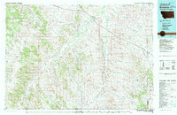 1980 Broadus1980 Print · USGSSoutheastern Montana and the Wyoming borderlands are captured in the early 1980s, centered on the high plains and river breaks of the Powder River. Genealogists and historians can trace old ranching outposts like Moorhead, Epsie, and Biddle alongside landmarks like the Two Tree Mine.
 - 1982 Map of Boyes
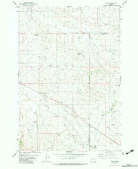 1982 Boyes1982 Print · USGSSoutheast Montana ranching country comes into focus in the early eighties as U.S. Route 212 cuts through the river valleys. Researchers can locate the Boyes Cem, the Hay Creek School, and landmarks like Morellas Butte.
End of results
Showing maps 1-2 of 2
Frequently asked questions
- What are the different types of historical maps available for Boyes?
- What is the oldest map of Boyes?
- Where can I purchase historical maps of Boyes for my home or office?
- Where can I download high-res historical maps of Boyes?
- Are there historical topographic maps available for Boyes?
- Is there historical aerial imagery available for Boyes?
- Where are historical maps of Boyes sourced from?