1900s (20th Century) Maps of Lowry, Montana
Explore 9 historic maps of Lowry from the 1900s (20th Century). These maps offer a rare glimpse into what life looked like during the 1900s — showing old roads, neighborhoods, homes, and landmarks that have changed or disappeared over time.
Whether you're researching your family's past, planning a metal detecting trip, or studying how Lowry's landscape evolved across the 1900s, these high-resolution maps are a powerful tool for exploring the history of this region.
- Focus on a specific era: All maps on this page are from the 1900s, giving you a focused view of this time period.
- See what’s changed: Compare century-old streets, trails, and buildings to today's modern landscape using overlays and satellite layers.
- Research with precision: Use these maps for genealogy, historical research, land use analysis, or educational projects.
- View, download, or print: Maps are fully viewable online in high resolution, and can be downloaded or printed for your own records.
Start exploring Lowry's history through authentic maps from the 1900s. This is your window into the past.
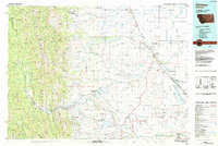
Lowry, MT maps
(9)- 1920 Map of Choteau
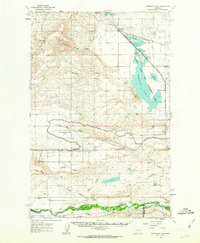
 1920 Choteau1920 Print · USGSNorth-central Montana in the early twentieth century shows a landscape being reshaped by irrigation canals and competing rail lines. Family historians can trace early settlements like Agawam, Bole, and Gilman, or locate regional landmarks like Priest Butte and Pishkun Reservoir.
 - 1955 Map of Choteau, 1978 Print
 1955 Choteau1978 Print · USGSWestern Montana during the mid-fifties is captured here as a land of rugged high-country wilderness and vital eastern plains irrigation. Genealogists and historians can locate remote outposts like Condon, the communal Miller Colony, and the rail stops of the Chicago Milwaukee St Paul and Pacific.
 - 1957 Map of Choteau
 1957 Choteau1957 Print · USGSMontana's mountain front meets the eastern plains in the mid-fifties, showing the transition from forested wilderness to irrigated ranch land. Genealogists and historians can trace the rail lines of the Great Northern and find settlements like Choteau, Augusta, and Seeley Lake.
 - 1958 Map of Choteau
 1958 Choteau1958 Print · USGSMontana's front range meets the high wilderness in the late fifties, where the Great Northern railway connects ranching towns to the eastern plains. Researchers can trace the development of irrigation at Bynum Reservoir or locate remote camps like the Big Prairie District Ranger Station and Helmville.2 unique versions available
 - 1960 Map of Freezeout Lake, 1963 Print
 1960 Freezeout Lake1963 Print · USGSThe Teton County plains are shown in the early sixties as a hub of irrigation and rail activity. Researchers can trace the water-management systems through Bole and Riebeling, or locate family landmarks like the Hamilton Ranch and School Section.2 unique versions available
 - 1962 Map of Choteau
 1962 Choteau1962 Print · USGSThe Rocky Mountain Front meets the western plains in the early 1960s, showing a landscape defined by the Continental Divide. Genealogists and researchers can trace the tracks of the Great Northern and find settlements like Choteau, Augusta, and Bynum.
 - 1976 Map of Choteau
 1976 Choteau1976 Print · USGSThe Montana Rocky Mountain Front meets the plains in the 1970s, showcasing the high-altitude wilderness and the irrigation-fed ranching country. Trace the Great Northern Railway through Choteau or locate rural landmarks like the Farmington Cemetery and Gibson Reservoir.
 - 1984 Map of Choteau
 1984 Choteau1984 Print · USGSThe Teton River country comes to life in this mid-eighties record of the Montana plains and mountains. Trace the footprints of early ranching and farming settlements like Farmington and Eastham Junction, or explore the unique Hutterite settlements at Miller Colony and New Rockport Colony.
 - 1987 Map of Lowry
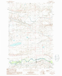 1987 Lowry1987 Print · USGSThe Montana high plains in the late eighties reveal a landscape defined by expansive irrigation projects and cattle ranching. Researchers can trace the path of the Greenfields Main Canal and locate rural landmarks like Lowry and the Hamilton Ranch.
End of results
Showing maps 1-9 of 9
Top cities near Lowry
Frequently asked questions
- What are the different types of historical maps available for Lowry?
- What is the oldest map of Lowry?
- Where can I purchase historical maps of Lowry for my home or office?
- Where can I download high-res historical maps of Lowry?
- Are there historical topographic maps available for Lowry?
- Is there historical aerial imagery available for Lowry?
- Where are historical maps of Lowry sourced from?