1990s Maps of Neihart, Montana
Explore 2 historic maps of Neihart from the 1990s. These maps offer a rare glimpse into what life looked like during the 1990s — showing old roads, neighborhoods, homes, and landmarks that have changed or disappeared over time.
Whether you're researching your family's past, planning a metal detecting trip, or studying how Neihart's landscape evolved across the 1990s, these high-resolution maps are a powerful tool for exploring the history of this region.
- Focus on a specific era: All maps on this page are from the 1990s, giving you a focused view of this time period.
- See what’s changed: Compare century-old streets, trails, and buildings to today's modern landscape using overlays and satellite layers.
- Research with precision: Use these maps for genealogy, historical research, land use analysis, or educational projects.
- View, download, or print: Maps are fully viewable online in high resolution, and can be downloaded or printed for your own records.
Start exploring Neihart's history through authentic maps from the 1990s. This is your window into the past.
Neihart, MT maps
(2)- 1995 Map of Neihart, 1997 Print
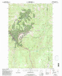 1995 Neihart1997 Print · USGSNeihart and the Little Belt Mountains are captured here in the mid-1990s, showcasing a landscape shaped by high-altitude mining. Genealogists and historians can locate numerous claims like the Silver Dyke Mine and Broadwater Mines near Neihart.
 - 1995 Map of Belt Park Butte, 1997 Print
 1995 Belt Park Butte1997 Print · USGSHigh in the Little Belts during the mid-nineties, this survey captures the mining and forest history of the Neihart area. Trace early land use through family-named landmarks like Johannesburg, Neihart Cem, and Rocking Chair Park.
End of results
Showing maps 1-2 of 2
Frequently asked questions
- What are the different types of historical maps available for Neihart?
- What is the oldest map of Neihart?
- Where can I purchase historical maps of Neihart for my home or office?
- Where can I download high-res historical maps of Neihart?
- Are there historical topographic maps available for Neihart?
- Is there historical aerial imagery available for Neihart?
- Where are historical maps of Neihart sourced from?