1900s (20th Century) Maps of Neihart, Montana
Explore 11 historic maps of Neihart from the 1900s (20th Century). These maps offer a rare glimpse into what life looked like during the 1900s — showing old roads, neighborhoods, homes, and landmarks that have changed or disappeared over time.
Whether you're researching your family's past, planning a metal detecting trip, or studying how Neihart's landscape evolved across the 1900s, these high-resolution maps are a powerful tool for exploring the history of this region.
- Focus on a specific era: All maps on this page are from the 1900s, giving you a focused view of this time period.
- See what’s changed: Compare century-old streets, trails, and buildings to today's modern landscape using overlays and satellite layers.
- Research with precision: Use these maps for genealogy, historical research, land use analysis, or educational projects.
- View, download, or print: Maps are fully viewable online in high resolution, and can be downloaded or printed for your own records.
Start exploring Neihart's history through authentic maps from the 1900s. This is your window into the past.
Neihart, MT maps
(11)- 1902 Map of Little Belt Mts.
 1902 Little Belt Mts.1902 Print · USGSMeagher County at the close of the nineteenth century is a landscape of mountain mining camps and riverside settlements. Researchers can trace early industry and family roots near the Sapphire Mine, the town of White Sulphur Springs, and the camp at Neihart.3 unique versions available
 - 1948 Map of White Sulphur Springs, 1951 Print
 1948 White Sulphur Springs1951 Print · USGSMontana's capital and the high country of the Big Belt Mountains come alive in this mid-century survey. Trace the early hydroelectric developments at Canyon Ferry Dam or follow the historic rail lines through Ringling and Townsend.
 - 1958 Map of White Sulphur Springs, 1968 Print
 1958 White Sulphur Springs1968 Print · USGSCentral Montana in the late fifties was a landscape of high-country mining and newly formed reservoirs. You can trace the rail-and-river economy of the era through sites like Canyon Ferry Lake, the East Pacific Mine, and the historic Fort Logan.3 unique versions available
 - 1961 Map of White Sulphur Springs
 1961 White Sulphur Springs1961 Print · USGSThe Missouri River valley and central Montana highlands are captured here during a period of significant hydroelectric and rail expansion. Genealogists and rail historians can trace the paths of the Northern Pacific and Chicago Milwaukee St Paul and Pacific through settlements like White Sulphur Springs and Townsend.
 - 1961 Map of Neihart, 1964 Print
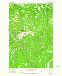 1961 Neihart1964 Print · USGSNeihart and the surrounding Little Belt Mountains are captured here in the early sixties, as the region's mining legacy remained etched into the landscape. Trace old workings at the Silver Dyke Mine or follow the waters of Belt Creek past Memorial Falls.2 unique versions available
 - 1961 Map of Neihart, 1965 Print
 1961 Neihart1965 Print · USGSThe mining district around Neihart and the Lewis and Clark National Forest come alive in this early 1960s survey. Researchers can trace deep-mountain legacy sites like the Silver Dyke Mine, Kings Hill Pass, and the Yogo Lookout Tower.2 unique versions available
 - 1965 Map of White Sulphur Springs
 1965 White Sulphur Springs1965 Print · USGSCentral Montana in the late 1950s and early 60s reveals a rugged mountain landscape shaped by the Missouri River and the emergence of the Canyon Ferry Reservoir. Genealogists and local historians can trace legacy ranching sites, the Northern Pacific rail line, and remote schoolhouses like Cottonwood School and Spokane Creek School.
 - 1967 Map of Belt Park Butte, 1969 Print
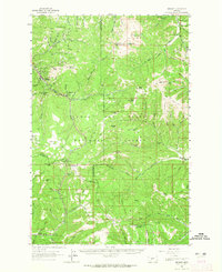
 1967 Belt Park Butte1969 Print · USGSIn the Little Belt Mountains during the 1960s, the silver-mining community of Neihart sits at the nexus of deep mountain gulches. Researchers can locate the Neihart Cem, trace the drainage of Slaughterhouse Gulch, and find old prospects near Belt Park Butte.2 unique versions available
 - 1984 Map of White Sulphur Springs
 1984 White Sulphur Springs1984 Print · USGSCentral Montana's mining and ranching corridors come to life in the mid-eighties, highlighting the high-country settlements of the Meagher and Judith Basin counties. Genealogists and historians can trace old mining claims like the Silver Dyke Mine and Broadwater Mines, or locate remote points like Checkerboard and Neihart.
 - 1995 Map of Neihart, 1997 Print
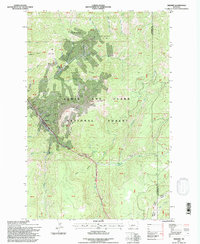 1995 Neihart1997 Print · USGSNeihart and the Little Belt Mountains are captured here in the mid-1990s, showcasing a landscape shaped by high-altitude mining. Genealogists and historians can locate numerous claims like the Silver Dyke Mine and Broadwater Mines near Neihart.
 - 1995 Map of Belt Park Butte, 1997 Print
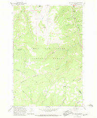
 1995 Belt Park Butte1997 Print · USGSHigh in the Little Belts during the mid-nineties, this survey captures the mining and forest history of the Neihart area. Trace early land use through family-named landmarks like Johannesburg, Neihart Cem, and Rocking Chair Park.
End of results
Showing maps 1-11 of 11
Frequently asked questions
- What are the different types of historical maps available for Neihart?
- What is the oldest map of Neihart?
- Where can I purchase historical maps of Neihart for my home or office?
- Where can I download high-res historical maps of Neihart?
- Are there historical topographic maps available for Neihart?
- Is there historical aerial imagery available for Neihart?
- Where are historical maps of Neihart sourced from?