Old Maps of Richey Trailer Court, Richey for Genealogy
Trace your family roots with 5 historic maps of Richey Trailer Court. These high-res maps reveal old neighborhoods, homesites, landmarks, and streets — helping you uncover where your ancestors lived and how the area evolved over time.
- Explore historic neighborhoods: Identify where your relatives may have lived in the 1800s or 1900s.
- Compare maps over time: Trace the changes in streets, buildings, and landmarks for multi-generational research.
- Perfect for genealogy & ancestry research: Used by family historians and researchers to map out lineage and migration.
These maps are an incredible resource for exploring your personal connection to Richey Trailer Court's past.
Richey Trailer Court, Richey maps
(5)- 1954 Map of Glendive, 1967 Print
 1954 Glendive1967 Print · USGSEastern Montana at mid-century shows a landscape of river-valley commerce and remote prairie ranching. Researchers can trace the legacy of rural education and transport through sites like Prairie Elk School, the Great Northern rail lines, and Circle.2 unique versions available
 - 1957 Map of Glendive
 1957 Glendive1957 Print · USGSEastern Montana in the mid-1950s is defined by its deep river valleys and a sprawling network of rural school districts. You can trace the path of the Great Northern railroad and locate vanished local landmarks like Breezy Flat School and Newton Junction.
 - 1958 Map of Glendive
 1958 Glendive1958 Print · USGSEastern Montana and the North Dakota borderlands come alive in the late fifties, showing the agricultural heart of the Yellowstone valley. Trace the legacy of rural education through Kimmel School and Ridgelawn School or locate rail hubs in Glendive and Sidney.
 - 1983 Map of Richey
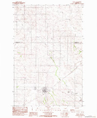 1983 Richey1983 Print · USGSThe plains of Dawson County come into focus in the early 1980s, centered on the small town of Richey. Genealogists and researchers can trace local water rights and land use through Keeland Reservoir, Wold Reservoir, and the forks of Lisk Creek.
 - 2024 Map of Richey, 2024 Print
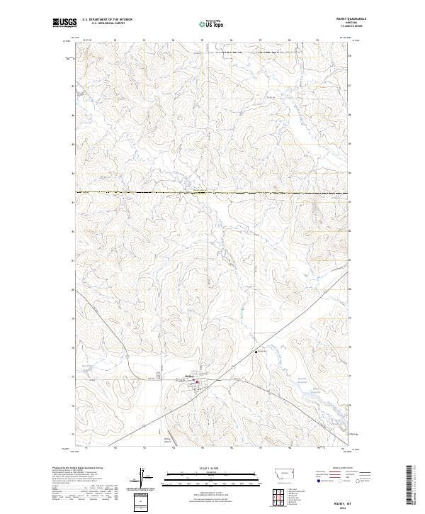 2024 Richey2024 Print · USGSRichey sits at the junction of Dawson and Richland counties in this modern topographic study of the Montana plains. Genealogists and local historians can trace the town's layout and find specific landmarks like the Richey Cem, Richey Airport, and Longs Reservoir.
End of results
Showing maps 1-5 of 5
Top cities near Richey Trailer Court
Frequently asked questions
- What are the different types of historical maps available for Richey Trailer Court?
- What is the oldest map of Richey Trailer Court?
- Where can I purchase historical maps of Richey Trailer Court for my home or office?
- Where can I download high-res historical maps of Richey Trailer Court?
- Are there historical topographic maps available for Richey Trailer Court?
- Is there historical aerial imagery available for Richey Trailer Court?
- Where are historical maps of Richey Trailer Court sourced from?