1970s Maps of Dosdon District, Montana
Explore 2 historic maps of Dosdon District from the 1970s. These maps offer a rare glimpse into what life looked like during the 1970s — showing old roads, neighborhoods, homes, and landmarks that have changed or disappeared over time.
Whether you're researching your family's past, planning a metal detecting trip, or studying how Dosdon District's landscape evolved across the 1970s, these high-resolution maps are a powerful tool for exploring the history of this region.
- Focus on a specific era: All maps on this page are from the 1970s, giving you a focused view of this time period.
- See what’s changed: Compare century-old streets, trails, and buildings to today's modern landscape using overlays and satellite layers.
- Research with precision: Use these maps for genealogy, historical research, land use analysis, or educational projects.
- View, download, or print: Maps are fully viewable online in high resolution, and can be downloaded or printed for your own records.
Start exploring Dosdon District's history through authentic maps from the 1970s. This is your window into the past.
Dosdon District, MT maps
(2)- 1971 Map of Big Flat East, 1974 Print
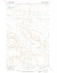 1971 Big Flat East1974 Print · USGSThe high plains of Phillips County and the eastern edge of the Fort Belknap Indian Reservation are documented here in the early 1970s. Researchers can trace the boundaries of the Fort Belknap Indian Reservation Boundary and drainage systems like Tressler Coulee and Wild Horse Creek.
 - 1971 Map of Big Flat West, 1975 Print
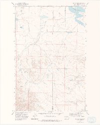 1971 Big Flat West1975 Print · USGSThe high plains of the Fort Belknap Indian Reservation are documented here in the early 1970s, showing the intersection of Blaine and Phillips counties. Researchers can trace the drainage of Big Flat through the network of Weigand Reservoir, Lone Tree Coulee, and Corral Coulee.2 unique versions available
End of results
Showing maps 1-2 of 2
Top cities near Dosdon District
Frequently asked questions
- What are the different types of historical maps available for Dosdon District?
- What is the oldest map of Dosdon District?
- Where can I purchase historical maps of Dosdon District for my home or office?
- Where can I download high-res historical maps of Dosdon District?
- Are there historical topographic maps available for Dosdon District?
- Is there historical aerial imagery available for Dosdon District?
- Where are historical maps of Dosdon District sourced from?