1900s (20th Century) Maps of Dosdon District, Montana
Explore 10 historic maps of Dosdon District from the 1900s (20th Century). These maps offer a rare glimpse into what life looked like during the 1900s — showing old roads, neighborhoods, homes, and landmarks that have changed or disappeared over time.
Whether you're researching your family's past, planning a metal detecting trip, or studying how Dosdon District's landscape evolved across the 1900s, these high-resolution maps are a powerful tool for exploring the history of this region.
- Focus on a specific era: All maps on this page are from the 1900s, giving you a focused view of this time period.
- See what’s changed: Compare century-old streets, trails, and buildings to today's modern landscape using overlays and satellite layers.
- Research with precision: Use these maps for genealogy, historical research, land use analysis, or educational projects.
- View, download, or print: Maps are fully viewable online in high resolution, and can be downloaded or printed for your own records.
Start exploring Dosdon District's history through authentic maps from the 1900s. This is your window into the past.
Dosdon District, MT maps
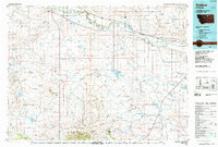
(10)- 1953 Map of Havre, 1967 Print
 1953 Havre1967 Print · USGSNorthern Montana’s Hi-Line comes into focus in the mid-fifties, centered on the Milk River and the critical Great Northern rail link. Genealogists can trace small sidings and settlements like Assinniboine, Laredo, and Box Elder alongside the Fort Belknap Agency.3 unique versions available
 - 1957 Map of Havre
 1957 Havre1957 Print · USGSNorth-central Montana at the mid-century is defined by the vital Great Northern rail corridor and the winding Milk River. Researchers can trace old settlements like Laredo and Savoy, or locate historic sites such as the Hays (old) Sub Agency and the Chinook No 1 mine.
 - 1958 Map of Havre
 1958 Havre1958 Print · USGSUpper Montana in the late fifties was a landscape of remote rail towns and vast high-plain ranges. Genealogists and historians can trace the Great Northern railroad through Havre, Chinook, and the Fort Belknap Indian Reservation.
 - 1964 Map of Coburg, 1967 Print
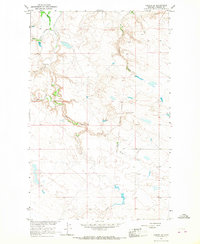
 1964 Coburg1967 Print · USGSThe rural plains of northern Montana are captured here in the 1960s, centered on the railroad siding of Coburg. Genealogists and historians can trace the Great Northern rail line and locate the Horn Cem near the banks of the Milk River.
 - 1964 Map of Coburg SE, 1967 Print
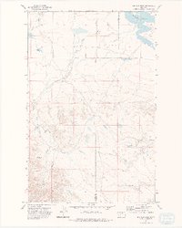
 1964 Coburg SE1967 Print · USGSPhillips County ranch land and reservation territory are captured here in the mid-1960s. Researchers can trace land use and water features along Peoples Creek, the Fort Belknap Indian Reservation Boundary, and East Belknap.
 - 1964 Map of Weigand Reservoir, 1967 Print
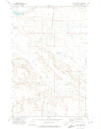
 1964 Weigand Reservoir1967 Print · USGSThe northern Montana prairie comes into focus during the 1960s, showing the intersection of the Fort Belknap Indian Reservation and the county line. Trace the local hydrology through landmarks like Weigand Reservoir, Old Woman Lake, and a rural Mine.
 - 1964 Map of Dodson Dam, 1968 Print
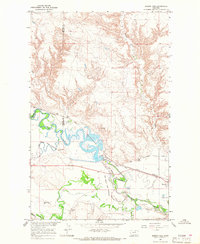 1964 Dodson Dam1968 Print · USGSPhillips County in the mid-1960s was a hub for Milk River irrigation and Great Northern rail traffic. Researchers can trace the Fort Belknap Indian Reservation Boundary, locate the Cem at Graveyard Hill, and follow the Dodson North Canal.
 - 1971 Map of Big Flat East, 1974 Print
 1971 Big Flat East1974 Print · USGSThe high plains of Phillips County and the eastern edge of the Fort Belknap Indian Reservation are documented here in the early 1970s. Researchers can trace the boundaries of the Fort Belknap Indian Reservation Boundary and drainage systems like Tressler Coulee and Wild Horse Creek.
 - 1971 Map of Big Flat West, 1975 Print
 1971 Big Flat West1975 Print · USGSThe high plains of the Fort Belknap Indian Reservation are documented here in the early 1970s, showing the intersection of Blaine and Phillips counties. Researchers can trace the drainage of Big Flat through the network of Weigand Reservoir, Lone Tree Coulee, and Corral Coulee.2 unique versions available
 - 1984 Map of Dodson, 1985 Print
 1984 Dodson1985 Print · USGSNorthern Montana ranching and reservation life are captured here in the mid-eighties as the Milk River valley sustains a string of railroad towns. Researchers can locate historic sites like Graveyard Hill, the Fort Belknap Agency, and several rural schoolhouses.
End of results
Showing maps 1-10 of 10
Top cities near Dosdon District
Frequently asked questions
- What are the different types of historical maps available for Dosdon District?
- What is the oldest map of Dosdon District?
- Where can I purchase historical maps of Dosdon District for my home or office?
- Where can I download high-res historical maps of Dosdon District?
- Are there historical topographic maps available for Dosdon District?
- Is there historical aerial imagery available for Dosdon District?
- Where are historical maps of Dosdon District sourced from?