1990s Maps of Heath, Montana
Explore 2 historic maps of Heath from the 1990s. These maps offer a rare glimpse into what life looked like during the 1990s — showing old roads, neighborhoods, homes, and landmarks that have changed or disappeared over time.
Whether you're researching your family's past, planning a metal detecting trip, or studying how Heath's landscape evolved across the 1990s, these high-resolution maps are a powerful tool for exploring the history of this region.
- Focus on a specific era: All maps on this page are from the 1990s, giving you a focused view of this time period.
- See what’s changed: Compare century-old streets, trails, and buildings to today's modern landscape using overlays and satellite layers.
- Research with precision: Use these maps for genealogy, historical research, land use analysis, or educational projects.
- View, download, or print: Maps are fully viewable online in high resolution, and can be downloaded or printed for your own records.
Start exploring Heath's history through authentic maps from the 1990s. This is your window into the past.
Heath, MT maps
(2)- 1993 Map of Big Snowy Mountains
 1993 Big Snowy Mountains1993 Print · USGSCentral Montana ranching and mountain landscapes come into focus in the early 1990s as small settlements like Judith Gap and Straw dot the plains. Genealogists and historians can trace the Burlington Northern rail line and identify remote sites like Living Springs or the Elephant Rocks.
 - 1995 Map of Heath, 1997 Print
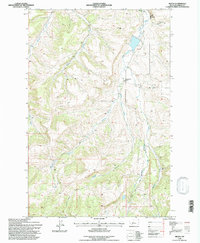 1995 Heath1997 Print · USGSFergus County's rural heartland is documented here in the mid-nineties, showing the community of Heath and the drainage networks of the Big Snowy foothills. Genealogists and historians can trace the Old Railroad Bed, Mountain View School, and the local Community Hall.
End of results
Showing maps 1-2 of 2
Top cities near Heath
Frequently asked questions
- What are the different types of historical maps available for Heath?
- What is the oldest map of Heath?
- Where can I purchase historical maps of Heath for my home or office?
- Where can I download high-res historical maps of Heath?
- Are there historical topographic maps available for Heath?
- Is there historical aerial imagery available for Heath?
- Where are historical maps of Heath sourced from?