Old Maps of Grayling, Montana
Explore 12 old maps of Grayling, spanning from 1955 to today. These high-resolution historic maps reveal how streets, neighborhoods, landmarks, and natural features evolved over time — perfect for genealogy, metal detecting, research, and local history exploration.
What you can do with these maps:
- See how Grayling changed over time: Compare historical maps to modern-day views to trace roads, homesites, rail lines & more.
- View detailed metadata: Each map includes creators, publishers, year, scale, and archive source.
- Overlay maps with satellite & LiDAR: Visualize the past alongside modern tools to explore terrain & human change.
- Trusted historical sources: Maps sourced from the USGS, Library of Congress, and other archives.
- Access maps your way: View online, download high-res files, or order prints for personal or research use.
Start exploring old maps of Grayling to uncover forgotten places, hidden landmarks, and the deep history beneath your feet.
Grayling, MT maps
(12)- 1955 Map of Ashton, 1967 Print
 1955 Ashton1967 Print · USGSThe Greater Yellowstone ecosystem is captured here during the mid-1950s, showing the high plateaus and remote gateway towns of Idaho and Montana. Researchers can trace the Union Pacific line to Ashton or locate small settlements like Squirrel and Grainville.4 unique versions available
 - 1958 Map of Ashton
 1958 Ashton1958 Print · USGSGreater Yellowstone and the eastern Idaho borderlands appear here in the mid-1950s as rail and road networks connected remote mountain basins. Trace the Union Pacific route through Ashton or locate early outposts like Last Chance, Squirrel, and West Yellowstone.
 - 1958 Map of Tepee Creek, 1960 Print
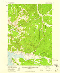 1958 Tepee Creek1960 Print · USGSThe high country of the Montana-Wyoming border is captured here in the late fifties, just prior to the 1959 earthquake. Genealogists and researchers can trace early recreation and forest outposts like Parade Rest Ranch, Cabin Creek Ranger Sta, and Edwards.2 unique versions available
 - 1960 Map of Ashton
 1960 Ashton1960 Print · USGSThe Idaho-Montana-Wyoming borderlands at the dawn of the sixties show a landscape defined by the Continental Divide and early wilderness tourism. Genealogists and historians can trace rail-stop settlements like Trude Siding, old outposts like Warm River, and early lodging at Snowball Inn.
 - 1986 Map of Mount Hebgen
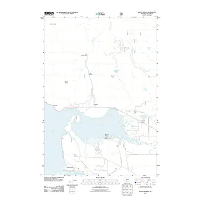
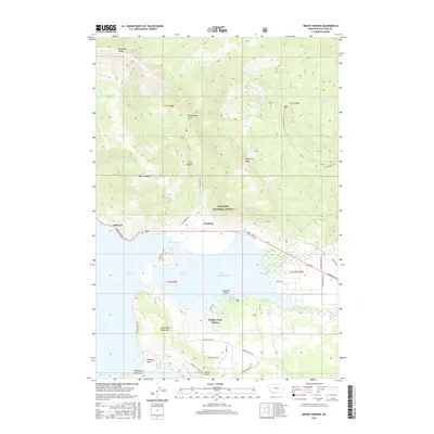
 1986 Mount Hebgen1986 Print · USGSGallatin County's high-country waters and ridges are documented here in the mid-1980s, featuring the detailed shoreline of Hebgen Lake. Researchers can trace the complex geography of Horse Butte Peninsula and landmarks like Rainbow Point or the Marina.
 - 1993 Map of Hebgen Lake
 1993 Hebgen Lake1993 Print · USGSThe high mountain passes and vast river basins of the Montana-Idaho border come into focus in the early nineties. Genealogists and historians can trace the remote settlement of Lakeview and the development of West Yellowstone near the Red Rock Lakes National Wildlife Refuge.2 unique versions available
 - 2000 Map of Mount Hebgen, 2005 Print
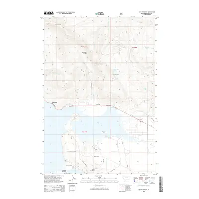
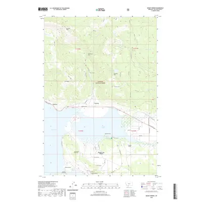
 2000 Mount Hebgen2005 Print · USGSGallatin County during the late twentieth century reveals a landscape defined by seismic history and lakeside recreation. Researchers can trace the shoreline settlements of Grayling and Lakeview or locate the geologic scars of the Red Canyon Fault.
 - 2011 Map of Mount Hebgen, 2011 Print
 2011 Mount Hebgen2011 Print · USGSCovers Grayling, including Horse Butte Acres Trailer Court, Lakeview, and other nearby areas
 - 2014 Map of Mount Hebgen, 2014 Print
 2014 Mount Hebgen2014 Print · USGSCovers Grayling, including Horse Butte Acres Trailer Court, Lakeview, and other nearby areas
 - 2017 Map of Mount Hebgen, 2017 Print
 2017 Mount Hebgen2017 Print · USGSCovers Grayling, including Horse Butte Acres Trailer Court, Lakeview, and other nearby areas
 - 2020 Map of Mount Hebgen, 2020 Print
 2020 Mount Hebgen2020 Print · USGSCovers Grayling, including Horse Butte Acres Trailer Court, Lakeview, and other nearby areas
 - 2024 Map of Mount Hebgen, 2024 Print
 2024 Mount Hebgen2024 Print · USGSGallatin County at the edge of the Madison Valley is shown here in detail during the early twenty-first century. Researchers can trace the development of Hebgen Lake Estates or explore the wilderness trails around Mt Hebgen and Johnson Lake.
End of results
Showing maps 1-12 of 12
Top cities near Grayling
Frequently asked questions
- What are the different types of historical maps available for Grayling?
- What is the oldest map of Grayling?
- Where can I purchase historical maps of Grayling for my home or office?
- Where can I download high-res historical maps of Grayling?
- Are there historical topographic maps available for Grayling?
- Is there historical aerial imagery available for Grayling?
- Where are historical maps of Grayling sourced from?