1970s Maps of Haxby, Montana
Explore 2 historic maps of Haxby from the 1970s. These maps offer a rare glimpse into what life looked like during the 1970s — showing old roads, neighborhoods, homes, and landmarks that have changed or disappeared over time.
Whether you're researching your family's past, planning a metal detecting trip, or studying how Haxby's landscape evolved across the 1970s, these high-resolution maps are a powerful tool for exploring the history of this region.
- Focus on a specific era: All maps on this page are from the 1970s, giving you a focused view of this time period.
- See what’s changed: Compare century-old streets, trails, and buildings to today's modern landscape using overlays and satellite layers.
- Research with precision: Use these maps for genealogy, historical research, land use analysis, or educational projects.
- View, download, or print: Maps are fully viewable online in high resolution, and can be downloaded or printed for your own records.
Start exploring Haxby's history through authentic maps from the 1970s. This is your window into the past.
Haxby, MT maps
(2)- 1972 Map of Norville Creek, 1975 Print
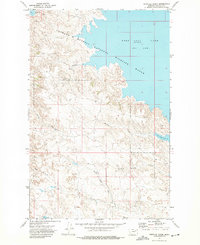 1972 Norville Creek1975 Print · USGSGarfield County in the early seventies shows a landscape defined by the waters of the Fort Peck Lake reservoir and its surrounding wildlife range. Researchers can trace the drainage patterns of Norville Creek or locate isolated landmarks like the Landing Strip and Drill Hole.
 - 1978 Map of Fort Peck Lake East
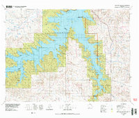 1978 Fort Peck Lake East1978 Print · USGSGarfield County, Montana, is shown here during the late 1970s as the rising waters of Fort Peck Lake reshaped the Missouri River breaks. Genealogists and local researchers can trace family-named sites like Collins Ranch, Keister School, and Rodgers Hall.2 unique versions available
End of results
Showing maps 1-2 of 2
Frequently asked questions
- What are the different types of historical maps available for Haxby?
- What is the oldest map of Haxby?
- Where can I purchase historical maps of Haxby for my home or office?
- Where can I download high-res historical maps of Haxby?
- Are there historical topographic maps available for Haxby?
- Is there historical aerial imagery available for Haxby?
- Where are historical maps of Haxby sourced from?