1960s Maps of Jordan, Montana
Explore 2 historic maps of Jordan from the 1960s. These maps offer a rare glimpse into what life looked like during the 1960s — showing old roads, neighborhoods, homes, and landmarks that have changed or disappeared over time.
Whether you're researching your family's past, planning a metal detecting trip, or studying how Jordan's landscape evolved across the 1960s, these high-resolution maps are a powerful tool for exploring the history of this region.
- Focus on a specific era: All maps on this page are from the 1960s, giving you a focused view of this time period.
- See what’s changed: Compare century-old streets, trails, and buildings to today's modern landscape using overlays and satellite layers.
- Research with precision: Use these maps for genealogy, historical research, land use analysis, or educational projects.
- View, download, or print: Maps are fully viewable online in high resolution, and can be downloaded or printed for your own records.
Start exploring Jordan's history through authentic maps from the 1960s. This is your window into the past.
Jordan, MT maps
(2)- 1964 Map of Jordan
 1964 Jordan1964 Print · USGSGarfield County and the surrounding Montana prairie are captured in the mid-1950s as the Fort Peck Reservoir reshapes the northern landscape. Local historians can trace the locations of rural schoolhouses like South First Creek School and remote ranching outposts such as Brusett and Van Norman.
 - 1964 Map of Jordan, 1967 Print
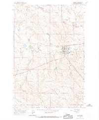 1964 Jordan1967 Print · USGSJordan in the mid-1960s serves as a hub for Garfield County ranching life near the banks of Big Dry Creek. Researchers can trace town development through the County Fairground, Pioneer Cem, and the grid of residential streets as they stood decades ago.2 unique versions available
End of results
Showing maps 1-2 of 2
Frequently asked questions
- What are the different types of historical maps available for Jordan?
- What is the oldest map of Jordan?
- Where can I purchase historical maps of Jordan for my home or office?
- Where can I download high-res historical maps of Jordan?
- Are there historical topographic maps available for Jordan?
- Is there historical aerial imagery available for Jordan?
- Where are historical maps of Jordan sourced from?