1900s (20th Century) Maps of Santa Rita, Montana
Explore 8 historic maps of Santa Rita from the 1900s (20th Century). These maps offer a rare glimpse into what life looked like during the 1900s — showing old roads, neighborhoods, homes, and landmarks that have changed or disappeared over time.
Whether you're researching your family's past, planning a metal detecting trip, or studying how Santa Rita's landscape evolved across the 1900s, these high-resolution maps are a powerful tool for exploring the history of this region.
- Focus on a specific era: All maps on this page are from the 1900s, giving you a focused view of this time period.
- See what’s changed: Compare century-old streets, trails, and buildings to today's modern landscape using overlays and satellite layers.
- Research with precision: Use these maps for genealogy, historical research, land use analysis, or educational projects.
- View, download, or print: Maps are fully viewable online in high resolution, and can be downloaded or printed for your own records.
Start exploring Santa Rita's history through authentic maps from the 1900s. This is your window into the past.
Santa Rita, MT maps
(8)- 1907 Map of Blackfoot Res.
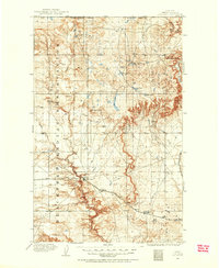
 1907 Blackfoot Res.1907 Print · USGSEarly twentieth-century northern Montana terrain comes into focus through this technical reclamation survey. Genealogists and researchers can trace the precise contours of the land across T.34 N. and T.32 N., locating specific early benchmarks like BM 3775.
 - 1909 Map of Cut Bank, 1955 Print
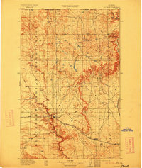
 1909 Cut Bank1955 Print · USGSHigh plains settlement and rail expansion define this Teton County landscape during the early twentieth century. Genealogists can trace the early rail stops of the Great Northern at Cut Bank, Ethridge, and Simla near the Blackfeet Indian Reservation boundary.
 - 1912 Map of Cut Bank
 1912 Cut Bank1912 Print · USGSNorthern Montana’s high plains and the Blackfeet Indian Reservation are captured here during the height of the homesteading era. Genealogists and historians can trace the early path of the Great Northern R R through Cut Bank and Simla.3 unique versions available
 - 1960 Map of Cut Bank, 1968 Print
 1960 Cut Bank1968 Print · USGSThe high peaks of the Rockies meet the eastern plains in the 1960s, showing the intersection of federal lands and the Blackfeet Indian Reservation. Trace the path of the Great Northern railway and find local landmarks like the Blackfoot Boarding School and Family Mission Cem.3 unique versions available
 - 1963 Map of Cut Bank
 1963 Cut Bank1963 Print · USGSNorthern Montana’s mountain passes and high plains are captured here in the early 1960s. Genealogists and historians can trace the Great Northern rail stops from Browning to Ethridge or locate the remote outposts at Polebridge and Babb.
 - 1964 Map of Cut Bank
 1964 Cut Bank1964 Print · USGSGlacier National Park and the Blackfeet Indian Reservation meet in the early sixties at the triple divide of North America. Researchers can trace the Great Northern Railway through mountain passes and locate local landmarks like the Blackfoot Boarding School and Apgar Village.
 - 1966 Map of Cut Bank, 1969 Print
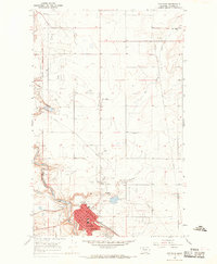 1966 Cut Bank1969 Print · USGSThe high plains of Glacier County are captured here in the mid-1960s as the energy and rail industries shaped the local landscape. Researchers can trace the Great Northern rail lines and locate rural landmarks like Santa Rita, Meadowbrook Sch, and the Crown Hill Cem.2 unique versions available
 - 1984 Map of Cut Bank
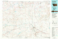 1984 Cut Bank1984 Print · USGSGlacier County's high plains are captured here in the mid-1980s, showcasing the intersection of tribal lands, energy development, and remote agricultural colonies. Genealogists and historians can trace the Burlington Northern rail line through settlements like Ethridge and Seville.
End of results
Showing maps 1-8 of 8
Top cities near Santa Rita
Frequently asked questions
- What are the different types of historical maps available for Santa Rita?
- What is the oldest map of Santa Rita?
- Where can I purchase historical maps of Santa Rita for my home or office?
- Where can I download high-res historical maps of Santa Rita?
- Are there historical topographic maps available for Santa Rita?
- Is there historical aerial imagery available for Santa Rita?
- Where are historical maps of Santa Rita sourced from?