1900s (20th Century) Maps of Saddle Butte, Montana
Explore 7 historic maps of Saddle Butte from the 1900s (20th Century). These maps offer a rare glimpse into what life looked like during the 1900s — showing old roads, neighborhoods, homes, and landmarks that have changed or disappeared over time.
Whether you're researching your family's past, planning a metal detecting trip, or studying how Saddle Butte's landscape evolved across the 1900s, these high-resolution maps are a powerful tool for exploring the history of this region.
- Focus on a specific era: All maps on this page are from the 1900s, giving you a focused view of this time period.
- See what’s changed: Compare century-old streets, trails, and buildings to today's modern landscape using overlays and satellite layers.
- Research with precision: Use these maps for genealogy, historical research, land use analysis, or educational projects.
- View, download, or print: Maps are fully viewable online in high resolution, and can be downloaded or printed for your own records.
Start exploring Saddle Butte's history through authentic maps from the 1900s. This is your window into the past.
Saddle Butte, MT maps
(7)- 1904 Map of Havre
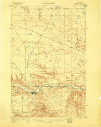 1904 Havre1904 Print · USGSHavre and the Milk River valley are captured in this early century survey as the region transitioned from a frontier military outpost to a railroad-driven settlement. Researchers can trace the original locations of numerous family homesteads like Conley's Ranch and Mc Grew's Ranch, alongside the sprawling Fort Assinniboine Mil. Res..2 unique versions available
 - 1912 Map of Thibedeau Lake
 1912 Thibedeau Lake1912 Print · USGSNorthern Montana's ranching frontier and rail corridors are captured here just after the turn of the century. Genealogists and historians can trace the early foundations of Havre and Fort Assinniboine, alongside family landmarks like Lohman's Ranch and Connolly Ranch.
 - 1953 Map of Havre, 1967 Print
 1953 Havre1967 Print · USGSNorthern Montana’s Hi-Line comes into focus in the mid-fifties, centered on the Milk River and the critical Great Northern rail link. Genealogists can trace small sidings and settlements like Assinniboine, Laredo, and Box Elder alongside the Fort Belknap Agency.3 unique versions available
 - 1957 Map of Havre
 1957 Havre1957 Print · USGSNorth-central Montana at the mid-century is defined by the vital Great Northern rail corridor and the winding Milk River. Researchers can trace old settlements like Laredo and Savoy, or locate historic sites such as the Hays (old) Sub Agency and the Chinook No 1 mine.
 - 1958 Map of Havre
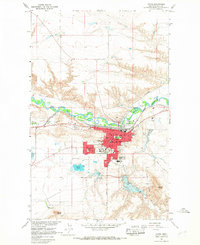
 1958 Havre1958 Print · USGSUpper Montana in the late fifties was a landscape of remote rail towns and vast high-plain ranges. Genealogists and historians can trace the Great Northern railroad through Havre, Chinook, and the Fort Belknap Indian Reservation.
 - 1964 Map of Havre, 1967 Print
 1964 Havre1967 Print · USGSHavre and the Milk River valley are shown here during the mid-1960s, a period of steady growth for this railroad and college town. Researchers can trace the development of Northern Montana College and locate local landmarks from Highland Cem to the Drive-in Theater.2 unique versions available
 - 1984 Map of Havre
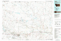 1984 Havre1984 Print · USGSThe Milk River valley and the northern high plains come into focus in the mid-1980s, detailing a landscape defined by rail, ranching, and water management. Trace the path of the Burlington Northern through Havre and Chinook, or locate sites like the Havre Air Force Station and Hilldale Colony.
End of results
Showing maps 1-7 of 7
Top cities near Saddle Butte
Frequently asked questions
- What are the different types of historical maps available for Saddle Butte?
- What is the oldest map of Saddle Butte?
- Where can I purchase historical maps of Saddle Butte for my home or office?
- Where can I download high-res historical maps of Saddle Butte?
- Are there historical topographic maps available for Saddle Butte?
- Is there historical aerial imagery available for Saddle Butte?
- Where are historical maps of Saddle Butte sourced from?