1950s Maps of Alhambra, Montana
Explore 2 historic maps of Alhambra from the 1950s. These maps offer a rare glimpse into what life looked like during the 1950s — showing old roads, neighborhoods, homes, and landmarks that have changed or disappeared over time.
Whether you're researching your family's past, planning a metal detecting trip, or studying how Alhambra's landscape evolved across the 1950s, these high-resolution maps are a powerful tool for exploring the history of this region.
- Focus on a specific era: All maps on this page are from the 1950s, giving you a focused view of this time period.
- See what’s changed: Compare century-old streets, trails, and buildings to today's modern landscape using overlays and satellite layers.
- Research with precision: Use these maps for genealogy, historical research, land use analysis, or educational projects.
- View, download, or print: Maps are fully viewable online in high resolution, and can be downloaded or printed for your own records.
Start exploring Alhambra's history through authentic maps from the 1950s. This is your window into the past.
Alhambra, MT maps
(2)- 1950 Map of Clancy, 1954 Print
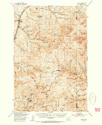 1950 Clancy1954 Print · USGSIn the mid-century Montana mountains, the mining district around Clancy and Elkhorn remains a network of high-altitude claims and forest outposts. Genealogists and historians can trace old operations like the Golden Age Mine and Elkhorn Skyline Mine or locate the Clancy Post Office.5 unique versions available
 - 1958 Map of White Sulphur Springs, 1968 Print
 1958 White Sulphur Springs1968 Print · USGSCentral Montana in the late fifties was a landscape of high-country mining and newly formed reservoirs. You can trace the rail-and-river economy of the era through sites like Canyon Ferry Lake, the East Pacific Mine, and the historic Fort Logan.3 unique versions available
End of results
Showing maps 1-2 of 2
Top cities near Alhambra
- Helena historical maps
- Montana City historical maps
- East Helena historical maps
- Clancy historical maps
- Boulder historical maps
Frequently asked questions
- What are the different types of historical maps available for Alhambra?
- What is the oldest map of Alhambra?
- Where can I purchase historical maps of Alhambra for my home or office?
- Where can I download high-res historical maps of Alhambra?
- Are there historical topographic maps available for Alhambra?
- Is there historical aerial imagery available for Alhambra?
- Where are historical maps of Alhambra sourced from?