1950s Maps of Comet, Montana
Explore 2 historic maps of Comet from the 1950s. These maps offer a rare glimpse into what life looked like during the 1950s — showing old roads, neighborhoods, homes, and landmarks that have changed or disappeared over time.
Whether you're researching your family's past, planning a metal detecting trip, or studying how Comet's landscape evolved across the 1950s, these high-resolution maps are a powerful tool for exploring the history of this region.
- Focus on a specific era: All maps on this page are from the 1950s, giving you a focused view of this time period.
- See what’s changed: Compare century-old streets, trails, and buildings to today's modern landscape using overlays and satellite layers.
- Research with precision: Use these maps for genealogy, historical research, land use analysis, or educational projects.
- View, download, or print: Maps are fully viewable online in high resolution, and can be downloaded or printed for your own records.
Start exploring Comet's history through authentic maps from the 1950s. This is your window into the past.
Comet, MT maps
(2)- 1950 Map of Jefferson City, 1952 Print
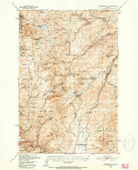 1950 Jefferson City1952 Print · USGSMining districts in Jefferson and Lewis and Clark Counties are shown in high detail during the early fifties. Trace the history of the Northern Pacific rail line and dozens of old workings like the Grey Eagle Mine and Rimini.5 unique versions available
 - 1958 Map of Butte
 1958 Butte1958 Print · USGSWestern Montana's mining and rail corridors are captured in the late fifties, from the urban bustle of the Copper King cities to high mountain passes. Researchers can trace the path of the Milwaukee St Paul and Pacific through Deer Lodge and locate remote outposts like Potomac Post Office.5 unique versions available
End of results
Showing maps 1-2 of 2
Top cities near Comet
Frequently asked questions
- What are the different types of historical maps available for Comet?
- What is the oldest map of Comet?
- Where can I purchase historical maps of Comet for my home or office?
- Where can I download high-res historical maps of Comet?
- Are there historical topographic maps available for Comet?
- Is there historical aerial imagery available for Comet?
- Where are historical maps of Comet sourced from?