1960s Maps of Hughesville, Montana
Explore 2 historic maps of Hughesville from the 1960s. These maps offer a rare glimpse into what life looked like during the 1960s — showing old roads, neighborhoods, homes, and landmarks that have changed or disappeared over time.
Whether you're researching your family's past, planning a metal detecting trip, or studying how Hughesville's landscape evolved across the 1960s, these high-resolution maps are a powerful tool for exploring the history of this region.
- Focus on a specific era: All maps on this page are from the 1960s, giving you a focused view of this time period.
- See what’s changed: Compare century-old streets, trails, and buildings to today's modern landscape using overlays and satellite layers.
- Research with precision: Use these maps for genealogy, historical research, land use analysis, or educational projects.
- View, download, or print: Maps are fully viewable online in high resolution, and can be downloaded or printed for your own records.
Start exploring Hughesville's history through authentic maps from the 1960s. This is your window into the past.
Hughesville, MT maps
(2)- 1961 Map of Barker, 1964 Print
 1961 Barker1964 Print · USGSDeep in the Little Belt Mountains during the early sixties, this map captures the mining legacy of Barker and Hughesville. Researchers can trace old prospecting routes like the Sawmill Trail and locate early Mines near Barker Mountain.
 - 1961 Map of Barker, 1966 Print
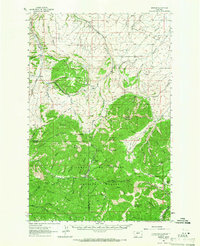 1961 Barker1966 Print · USGSThe mining camps of Judith Basin are documented here in the early sixties, showing the remote peaks of the Little Belt Mountains. Genealogists and historians can trace the foundations of Barker and Hughesville, or find the Barker Cem and Chambers Mine.2 unique versions available
End of results
Showing maps 1-2 of 2
Top cities near Hughesville
Frequently asked questions
- What are the different types of historical maps available for Hughesville?
- What is the oldest map of Hughesville?
- Where can I purchase historical maps of Hughesville for my home or office?
- Where can I download high-res historical maps of Hughesville?
- Are there historical topographic maps available for Hughesville?
- Is there historical aerial imagery available for Hughesville?
- Where are historical maps of Hughesville sourced from?