1990s Maps of Orchard Hills Mobile Home Park, Montana
Explore 2 historic maps of Orchard Hills Mobile Home Park from the 1990s. These maps offer a rare glimpse into what life looked like during the 1990s — showing old roads, neighborhoods, homes, and landmarks that have changed or disappeared over time.
Whether you're researching your family's past, planning a metal detecting trip, or studying how Orchard Hills Mobile Home Park's landscape evolved across the 1990s, these high-resolution maps are a powerful tool for exploring the history of this region.
- Focus on a specific era: All maps on this page are from the 1990s, giving you a focused view of this time period.
- See what’s changed: Compare century-old streets, trails, and buildings to today's modern landscape using overlays and satellite layers.
- Research with precision: Use these maps for genealogy, historical research, land use analysis, or educational projects.
- View, download, or print: Maps are fully viewable online in high resolution, and can be downloaded or printed for your own records.
Start exploring Orchard Hills Mobile Home Park's history through authentic maps from the 1990s. This is your window into the past.
Orchard Hills Mobile Home Park, MT maps
(2)- 1991 Map of Bigfork, 1995 Print
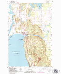 1991 Bigfork1995 Print · USGSThe northeast shores of Flathead Lake come alive in the 1990s as the community of Bigfork grows around its river mouth. Genealogists and historians can trace local settlements from Holt to Woods Bay, and locate landmarks like Bethany Ch and the Bigfork Dam.
 - 1994 Map of Bigfork, 1996 Print
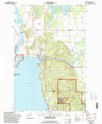 1994 Bigfork1996 Print · USGSThe northeastern shores of Flathead Lake come into focus in the mid-1990s as the community of Bigfork expands at the Swan River's mouth. Researchers can trace local landmarks like Little Brown Ch, the Bigfork Dam, and the early layout of Ferndale and Holt.
End of results
Showing maps 1-2 of 2
Top cities near Orchard Hills Mobile Home Park
Frequently asked questions
- What are the different types of historical maps available for Orchard Hills Mobile Home Park?
- What is the oldest map of Orchard Hills Mobile Home Park?
- Where can I purchase historical maps of Orchard Hills Mobile Home Park for my home or office?
- Where can I download high-res historical maps of Orchard Hills Mobile Home Park?
- Are there historical topographic maps available for Orchard Hills Mobile Home Park?
- Is there historical aerial imagery available for Orchard Hills Mobile Home Park?
- Where are historical maps of Orchard Hills Mobile Home Park sourced from?