Old Maps of Orchard Hills Mobile Home Park, Montana for Metal Detecting
Plan your next treasure hunt with 13 historic maps of Orchard Hills Mobile Home Park. Find old homesites, ghost towns, trails, and gathering spots that may be lost to time — perfect for identifying promising metal detecting locations.
- Locate forgotten sites: Uncover places like long-lost settlements, abandoned rail lines, or gathering spots.
- Plan better hunts: Use map overlays combined with LiDAR or satellite views to narrow in on historically rich areas.
- Made for detectorists: Thousands of hobbyists use these maps to discover relics, coins, and hidden history.
Use these historic maps to boost your research and find new opportunities beneath the surface of Orchard Hills Mobile Home Park.
Orchard Hills Mobile Home Park, MT maps
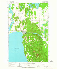
(13)- 1943 Map of Kalispell
 1943 Kalispell1943 Print · USGSThe Flathead Valley's mid-century rail and river networks are preserved here as Kalispell expanded. Genealogists and historians can trace defunct river crossings like Therriaults Ferry, the old Demersville site, and the rail path of the Somers Kalispell Br.
 - 1957 Map of Kalispell, 1967 Print
 1957 Kalispell1967 Print · USGSNorthwest Montana in the late fifties showcases a mountain landscape transitioning between wilderness and industry. Genealogists and researchers can trace the Great Northern rail corridor through Kalispell and Whitefish, or locate landmarks like the Montana Soldiers Home and Hungry Horse Reservoir.3 unique versions available
 - 1960 Map of Kalispell
 1960 Kalispell1960 Print · USGSNorthwest Montana in the late fifties is defined by the mountain corridors of the Great Northern Railway and the vast reaches of Glacier National Park. Researchers can trace the legacy of timber and mining towns like Libby, Rexford, and Whitefish, or locate landmarks such as the Snowshoe Mine.
 - 1961 Map of Kalispell
 1961 Kalispell1961 Print · USGSNorthwestern Montana at the start of the 1960s shows a landscape of timber-driven rail towns and the sprawling wild lands of Glacier National Park. Genealogists and historians can trace the route of the Great Northern through mountain passes or locate old settlements like Fortine, Trego, and Warland.
 - 1962 Map of Bigfork, 1964 Print
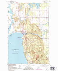
 1962 Bigfork1964 Print · USGSThe Flathead Valley and the shores of Bigfork are captured here during the early sixties, showing a landscape of timber management and lakeside settlement. Researchers can locate the Big Fork Dam, the McCaffery Lookout Tower, and local landmarks like Little Brown Ch and Bethany Ch.3 unique versions available
 - 1981 Map of Kalispell, 1982 Print
 1981 Kalispell1982 Print · USGSThe Flathead Valley in the early eighties shows a landscape defined by timber, tourism, and transit. Genealogists and historians can trace the growth of Evergreen, Bigfork, and Somers or locate early aviation landmarks like the Glacier Park Intl Airport.
 - 1991 Map of Bigfork, 1995 Print
 1991 Bigfork1995 Print · USGSThe northeast shores of Flathead Lake come alive in the 1990s as the community of Bigfork grows around its river mouth. Genealogists and historians can trace local settlements from Holt to Woods Bay, and locate landmarks like Bethany Ch and the Bigfork Dam.
 - 1994 Map of Bigfork, 1996 Print
 1994 Bigfork1996 Print · USGSThe northeastern shores of Flathead Lake come into focus in the mid-1990s as the community of Bigfork expands at the Swan River's mouth. Researchers can trace local landmarks like Little Brown Ch, the Bigfork Dam, and the early layout of Ferndale and Holt.
 - 2011 Map of Bigfork, 2011 Print
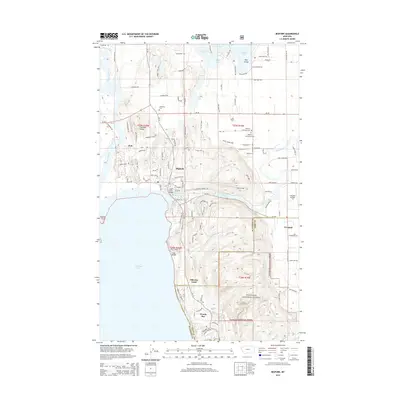
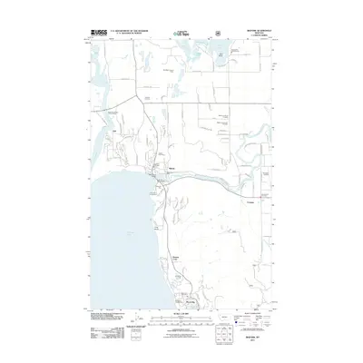 2011 Bigfork2011 Print · USGSCovers Orchard Hills Mobile Home Park, including Ferndale Mobile Court, Holt, and other nearby areas
 - 2014 Map of Bigfork, 2014 Print
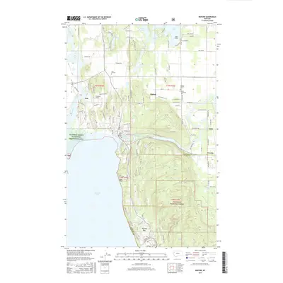
 2014 Bigfork2014 Print · USGSCovers Orchard Hills Mobile Home Park, including Ferndale Mobile Court, Holt, and other nearby areas
 - 2017 Map of Bigfork, 2017 Print
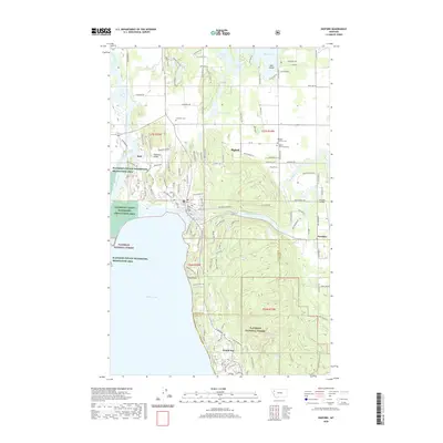
 2017 Bigfork2017 Print · USGSCovers Orchard Hills Mobile Home Park, including Ferndale Mobile Court, Holt, and other nearby areas
 - 2020 Map of Bigfork, 2020 Print
 2020 Bigfork2020 Print · USGSCovers Orchard Hills Mobile Home Park, including Ferndale Mobile Court, Holt, and other nearby areas
 - 2024 Map of Bigfork, 2024 Print
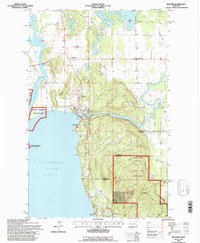
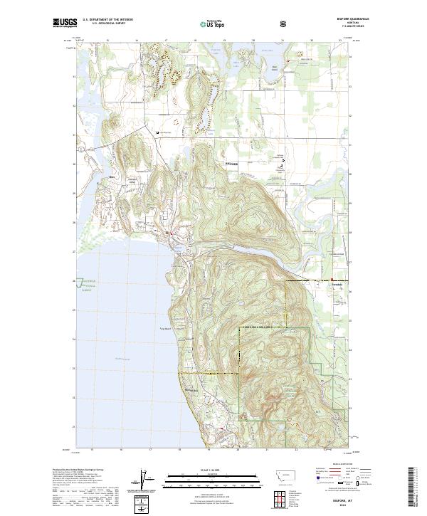 2024 Bigfork2024 Print · USGSBigfork and the northeastern shores of Flathead Lake are mapped in detail during the 2020s. Genealogists and historians can locate Lone Pine Cem, Bigfork Community Cem, and the old settlement of Holt north of the harbor.
End of results
Showing maps 1-13 of 13
Top cities near Orchard Hills Mobile Home Park
Frequently asked questions
- What are the different types of historical maps available for Orchard Hills Mobile Home Park?
- What is the oldest map of Orchard Hills Mobile Home Park?
- Where can I purchase historical maps of Orchard Hills Mobile Home Park for my home or office?
- Where can I download high-res historical maps of Orchard Hills Mobile Home Park?
- Are there historical topographic maps available for Orchard Hills Mobile Home Park?
- Is there historical aerial imagery available for Orchard Hills Mobile Home Park?
- Where are historical maps of Orchard Hills Mobile Home Park sourced from?