1970s Maps of Helena Valley Northeast, Lewis and Clark County
Explore 2 historic maps of Helena Valley Northeast from the 1970s. These maps offer a rare glimpse into what life looked like during the 1970s — showing old roads, neighborhoods, homes, and landmarks that have changed or disappeared over time.
Whether you're researching your family's past, planning a metal detecting trip, or studying how Helena Valley Northeast's landscape evolved across the 1970s, these high-resolution maps are a powerful tool for exploring the history of this region.
- Focus on a specific era: All maps on this page are from the 1970s, giving you a focused view of this time period.
- See what’s changed: Compare century-old streets, trails, and buildings to today's modern landscape using overlays and satellite layers.
- Research with precision: Use these maps for genealogy, historical research, land use analysis, or educational projects.
- View, download, or print: Maps are fully viewable online in high resolution, and can be downloaded or printed for your own records.
Start exploring Helena Valley Northeast's history through authentic maps from the 1970s. This is your window into the past.
Helena Valley Northeast, Lewis and Clark County maps
(2)- 1972 Map of Lake Helena, 1975 Print
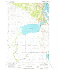 1972 Lake Helena1975 Print · USGSThe Helena Valley in the mid-1970s shows a complex network of irrigation canals and rural institutions centered around Lake Helena. Researchers can trace old school sites like Mountain View Sch, the Masonic Home, and early mining activity at Prospects.2 unique versions available
 - 1975 Map of Canyon Ferry Dam, 1994 Print
 1975 Canyon Ferry Dam1994 Print · USGSThe Missouri River and Big Belt Mountains define this Montana landscape during the mid-seventies. Genealogists and historians can trace old mining sites like the Snowback Mine and industrial settlements including White City and Louisville.
End of results
Showing maps 1-2 of 2
Frequently asked questions
- What are the different types of historical maps available for Helena Valley Northeast?
- What is the oldest map of Helena Valley Northeast?
- Where can I purchase historical maps of Helena Valley Northeast for my home or office?
- Where can I download high-res historical maps of Helena Valley Northeast?
- Are there historical topographic maps available for Helena Valley Northeast?
- Is there historical aerial imagery available for Helena Valley Northeast?
- Where are historical maps of Helena Valley Northeast sourced from?