Old Maps of Beacon Point, Montana for Genealogy
Trace your family roots with 12 historic maps of Beacon Point. These high-res maps reveal old neighborhoods, homesites, landmarks, and streets — helping you uncover where your ancestors lived and how the area evolved over time.
- Explore historic neighborhoods: Identify where your relatives may have lived in the 1800s or 1900s.
- Compare maps over time: Trace the changes in streets, buildings, and landmarks for multi-generational research.
- Perfect for genealogy & ancestry research: Used by family historians and researchers to map out lineage and migration.
These maps are an incredible resource for exploring your personal connection to Beacon Point's past.
Beacon Point, MT maps
(12)- 1888 Map of Three Forks
 1888 Three Forks1888 Print · USGSCovers Beacon Point, including Bozeman, Belgrade, and other nearby areas
 - 1894 Map of Three Forks
 1894 Three Forks1894 Print · USGSCovers Beacon Point, including Bozeman, Belgrade, and other nearby areas
 - 1895 Map of Three Forks
 1895 Three Forks1895 Print · USGSCovers Beacon Point, including Bozeman, Belgrade, and other nearby areas5 unique versions available
 - 1947 Map of Bozeman, 1948 Print
 1947 Bozeman1948 Print · USGSCovers Beacon Point, including Bozeman, Belgrade, and other nearby areas
 - 1948 Map of Bozeman, 1951 Print
 1948 Bozeman1951 Print · USGSCovers Beacon Point, including Bozeman, Belgrade, and other nearby areas
 - 1950 Map of Spanish Peaks, 1954 Print
 1950 Spanish Peaks1954 Print · USGSCovers Beacon Point, including Big Sky, Big Sky Mountain Village, and other nearby areas4 unique versions available
 - 1955 Map of Bozeman
 1955 Bozeman1955 Print · USGSCovers Beacon Point, including Bozeman, Belgrade, and other nearby areas
 - 1958 Map of Bozeman, 1968 Print
 1958 Bozeman1968 Print · USGSCovers Beacon Point, including Bozeman, Belgrade, and other nearby areas3 unique versions available
 - 1965 Map of Bozeman
 1965 Bozeman1965 Print · USGSCovers Beacon Point, including Bozeman, Belgrade, and other nearby areas
 - 1988 Map of Beacon Point, 1989 Print
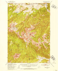
 1988 Beacon Point1989 Print · USGSCovers Beacon Point, including Gallatin County, Madison County, and other nearby areas2 unique versions available
 - 1989 Map of Ennis, 1990 Print
 1989 Ennis1990 Print · USGSCovers Beacon Point, including Big Sky, Ennis, and other nearby areas
 - 2000 Map of Beacon Point, 2005 Print
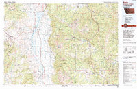
 2000 Beacon Point2005 Print · USGSCovers Beacon Point, including Gallatin County, Madison County, and other nearby areas
End of results
Showing maps 1-12 of 12
Top cities near Beacon Point
Frequently asked questions
- What are the different types of historical maps available for Beacon Point?
- What is the oldest map of Beacon Point?
- Where can I purchase historical maps of Beacon Point for my home or office?
- Where can I download high-res historical maps of Beacon Point?
- Are there historical topographic maps available for Beacon Point?
- Is there historical aerial imagery available for Beacon Point?
- Where are historical maps of Beacon Point sourced from?