1980s Maps of Watkins, Montana
Explore 2 historic maps of Watkins from the 1980s. These maps offer a rare glimpse into what life looked like during the 1980s — showing old roads, neighborhoods, homes, and landmarks that have changed or disappeared over time.
Whether you're researching your family's past, planning a metal detecting trip, or studying how Watkins's landscape evolved across the 1980s, these high-resolution maps are a powerful tool for exploring the history of this region.
- Focus on a specific era: All maps on this page are from the 1980s, giving you a focused view of this time period.
- See what’s changed: Compare century-old streets, trails, and buildings to today's modern landscape using overlays and satellite layers.
- Research with precision: Use these maps for genealogy, historical research, land use analysis, or educational projects.
- View, download, or print: Maps are fully viewable online in high resolution, and can be downloaded or printed for your own records.
Start exploring Watkins's history through authentic maps from the 1980s. This is your window into the past.
Watkins, MT maps
(2)- 1988 Map of Ennis Lake, 1989 Print
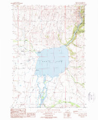 1988 Ennis Lake1989 Print · USGSNear the end of the twentieth century, Ennis Lake served as a central hub for recreation and irrigation in Madison County. Researchers can trace land details from the Cem near McAllister to the wild reaches of Bear Trap Canyon.2 unique versions available
 - 1989 Map of Ennis, 1990 Print
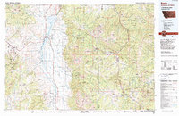 1989 Ennis1990 Print · USGSMadison County ranching and the rise of mountain tourism define this region during the 1980s. Genealogists and historians can trace the development of Ennis, find historic mining sites like the Missouri Mine, or locate the settlements at Virginia City and McAllister.
End of results
Showing maps 1-2 of 2
Top cities near Watkins
Frequently asked questions
- What are the different types of historical maps available for Watkins?
- What is the oldest map of Watkins?
- Where can I purchase historical maps of Watkins for my home or office?
- Where can I download high-res historical maps of Watkins?
- Are there historical topographic maps available for Watkins?
- Is there historical aerial imagery available for Watkins?
- Where are historical maps of Watkins sourced from?