1990s Maps of Robinson, Montana
Explore 2 historic maps of Robinson from the 1990s. These maps offer a rare glimpse into what life looked like during the 1990s — showing old roads, neighborhoods, homes, and landmarks that have changed or disappeared over time.
Whether you're researching your family's past, planning a metal detecting trip, or studying how Robinson's landscape evolved across the 1990s, these high-resolution maps are a powerful tool for exploring the history of this region.
- Focus on a specific era: All maps on this page are from the 1990s, giving you a focused view of this time period.
- See what’s changed: Compare century-old streets, trails, and buildings to today's modern landscape using overlays and satellite layers.
- Research with precision: Use these maps for genealogy, historical research, land use analysis, or educational projects.
- View, download, or print: Maps are fully viewable online in high resolution, and can be downloaded or printed for your own records.
Start exploring Robinson's history through authentic maps from the 1990s. This is your window into the past.
Robinson, MT maps
(2)- 1993 Map of Ringling
 1993 Ringling1993 Print · USGSMeagher County in the early nineties remains a landscape of high-altitude ranching and mining history framed by the Crazy Mountains. Researchers can trace the legacy of the silver boom at Castle Town and the Cumberland Mine or locate early rail sidings like Loweth and Bruno.
 - 1995 Map of Castle Town, 1997 Print
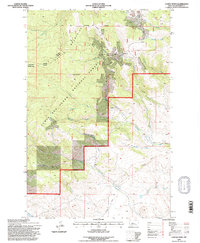 1995 Castle Town1997 Print · USGSThe Castle Mountains mining district is captured here during the mid-nineties, showing the enduring footprint of silver-era industry. Genealogists and historians can trace the foundations of Castle Town and Robinson or locate remote sites like the Cumberland Mine and Castle Cem.2 unique versions available
End of results
Showing maps 1-2 of 2
Top cities near Robinson
Frequently asked questions
- What are the different types of historical maps available for Robinson?
- What is the oldest map of Robinson?
- Where can I purchase historical maps of Robinson for my home or office?
- Where can I download high-res historical maps of Robinson?
- Are there historical topographic maps available for Robinson?
- Is there historical aerial imagery available for Robinson?
- Where are historical maps of Robinson sourced from?