1900s (20th Century) Maps of Lolo Hot Springs, Montana
Explore 9 historic maps of Lolo Hot Springs from the 1900s (20th Century). These maps offer a rare glimpse into what life looked like during the 1900s — showing old roads, neighborhoods, homes, and landmarks that have changed or disappeared over time.
Whether you're researching your family's past, planning a metal detecting trip, or studying how Lolo Hot Springs's landscape evolved across the 1900s, these high-resolution maps are a powerful tool for exploring the history of this region.
- Focus on a specific era: All maps on this page are from the 1900s, giving you a focused view of this time period.
- See what’s changed: Compare century-old streets, trails, and buildings to today's modern landscape using overlays and satellite layers.
- Research with precision: Use these maps for genealogy, historical research, land use analysis, or educational projects.
- View, download, or print: Maps are fully viewable online in high resolution, and can be downloaded or printed for your own records.
Start exploring Lolo Hot Springs's history through authentic maps from the 1900s. This is your window into the past.
Lolo Hot Springs, MT maps
(9)- 1911 Map of Lolo, 1954 Print
 1911 Lolo1954 Print · USGSThe Bitterroot wilderness at the dawn of the Forest Service era is documented here through its early camps and trail networks. Researchers can locate remote outposts like Moose City, the Clearwater Gold and Copper Company, and the historic Indian Post Office landmark.
 - 1913 Map of Lolo
 1913 Lolo1913 Print · USGSThe Bitterroot wilderness of the early 1900s is documented here through a web of mining camps, ranger stations, and high mountain passes. Genealogists and researchers can locate remote sites like Moose City, Williams Ranch, and the Clearwater Gold and Copper Company.2 unique versions available
 - 1956 Map of Hamilton, 1970 Print
 1956 Hamilton1970 Print · USGSThe Bitterroot Valley and surrounding high country are captured here during the mid-fifties, showing the region's transition into a modern forest-and-rail hub. Genealogists and historians can trace family-named sites and early infrastructure from Fort Missoula to towns like Stevensville and Darby along the Northern Pacific line.2 unique versions available
 - 1959 Map of Hamilton
 1959 Hamilton1959 Print · USGSThe Bitterroot Valley and surrounding wilderness are captured in the late fifties, showing a landscape defined by forestry and river-based settlement. Researchers can trace the Lolo Trail or locate historical points like Fort Missoula and the Fred Burr Reservoir.
 - 1960 Map of Hamilton
 1960 Hamilton1960 Print · USGSThe Bitterroot Valley and surrounding high country are captured here during the late fifties, showing the region's transition into a modern forest and rail corridor. Researchers can trace the path of the Northern Pacific through Missoula or locate landmarks like Fort Missoula and Lake Como.
 - 1964 Map of Hamilton
 1964 Hamilton1964 Print · USGSThe Bitterroot Valley and its surrounding peaks are captured in detail during the mid-1960s, showing the early infrastructure of the Northern Rockies. Genealogists and historians can trace family roots in Hamilton and Stevensville or follow the historic Lolo Trail and Nez Perce Trail.
 - 1964 Map of Lolo Hot Springs, 1967 Print
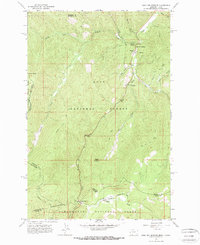 1964 Lolo Hot Springs1967 Print · USGSThe Bitterroot high country along the Montana and Idaho border comes into focus in the mid-1960s. Trace the paths of early forest travel through Lolo Pass, find the State Line Cabin, and locate landmarks like Snowshoe Falls and Packer Meadows.3 unique versions available
 - 1981 Map of Missoula West
 1981 Missoula West1981 Print · USGSThe Bitterroot Valley and the rugged Bitterroot Range are captured here in the early 1980s, documenting the expansion of Missoula and its outlying timber and river towns. Researchers can trace the Burlington Northern rail corridors or locate remote landmarks like Lolo Hot Springs and Lolo Pass.2 unique versions available
 - 1999 Map of Lolo Hot Springs, 2003 Print
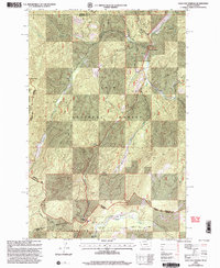 1999 Lolo Hot Springs2003 Print · USGSThe Bitterroot Range at the turn of the millennium marks a storied crossing between Montana and Idaho. Geographers and historians can trace high-altitude routes through Packer Meadows and locate established forest sites like the State Line Cabin and Lolo Hot Springs.
End of results
Showing maps 1-9 of 9
Frequently asked questions
- What are the different types of historical maps available for Lolo Hot Springs?
- What is the oldest map of Lolo Hot Springs?
- Where can I purchase historical maps of Lolo Hot Springs for my home or office?
- Where can I download high-res historical maps of Lolo Hot Springs?
- Are there historical topographic maps available for Lolo Hot Springs?
- Is there historical aerial imagery available for Lolo Hot Springs?
- Where are historical maps of Lolo Hot Springs sourced from?