1980s Maps of Jens, Montana
Explore 2 historic maps of Jens from the 1980s. These maps offer a rare glimpse into what life looked like during the 1980s — showing old roads, neighborhoods, homes, and landmarks that have changed or disappeared over time.
Whether you're researching your family's past, planning a metal detecting trip, or studying how Jens's landscape evolved across the 1980s, these high-resolution maps are a powerful tool for exploring the history of this region.
- Focus on a specific era: All maps on this page are from the 1980s, giving you a focused view of this time period.
- See what’s changed: Compare century-old streets, trails, and buildings to today's modern landscape using overlays and satellite layers.
- Research with precision: Use these maps for genealogy, historical research, land use analysis, or educational projects.
- View, download, or print: Maps are fully viewable online in high resolution, and can be downloaded or printed for your own records.
Start exploring Jens's history through authentic maps from the 1980s. This is your window into the past.
Jens, MT maps
(2)- 1984 Map of Missoula East
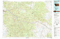 1984 Missoula East1984 Print · USGSThe Clark Fork valley and the Garnet Range are shown here in the mid-1980s as the region's timber and rail heritage remained prominent. Researchers can trace the Burlington Northern line and locate old mining sites like Garnet and the Copper Cliff Mine.
 - 1989 Map of Dunkleberg Creek
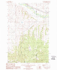 1989 Dunkleberg Creek1989 Print · USGSGranite and Powell Counties were centers of mountain industry in the 1980s, balancing timber management with high-altitude mining. Researchers can trace historical extraction at the Forest Rose Mine or follow the Old Railroad Grade past the settlement of Jens.
End of results
Showing maps 1-2 of 2
Top cities near Jens
Frequently asked questions
- What are the different types of historical maps available for Jens?
- What is the oldest map of Jens?
- Where can I purchase historical maps of Jens for my home or office?
- Where can I download high-res historical maps of Jens?
- Are there historical topographic maps available for Jens?
- Is there historical aerial imagery available for Jens?
- Where are historical maps of Jens sourced from?