Old Maps of Alta, Montana for Academic Research
Study the evolution of Alta with 11 high-resolution historic maps. Whether you're teaching, researching, or modeling changes in land use, these maps provide essential visual documentation of urban, environmental, and geographic change.
- Analyze long-term change: Track patterns in development, transportation, and natural features.
- Ideal for environmental or urban studies: Support academic projects with primary historical map data.
- Use in the classroom or lab: Educators and researchers rely on these maps to bring historical context to life.
These maps are a powerful tool for teaching, research, and visualizing how Alta has changed over the decades.
Alta, MT maps
(11)- 1956 Map of Elk City, 1963 Print
 1956 Elk City1963 Print · USGSThe Idaho backcountry in the mid-fifties remains a landscape of isolated mining camps and remote forest outposts. Researchers can trace historical mining operations at Stibnite Mine and Blackbird Mine or locate riverside landmarks like Mackay Bar and Campbell's Ferry.3 unique versions available
 - 1960 Map of Elk City
 1960 Elk City1960 Print · USGSThe Central Idaho wilderness and Bitterroot Range are captured here during the peak of mid-century industrial mining. Researchers can trace remote backcountry settlements like Burgdorf and Warren, alongside major mineral sites including the Blackbird Mine and Ima Mine.2 unique versions available
 - 1960 Map of Painted Rocks Lake, 1961 Print
 1960 Painted Rocks Lake1961 Print · USGSThe Bitterroot mountains of western Montana are documented here in the early sixties, showing the remote canyon lands at the state border. Trace historic mountain routes like the Nez Perce Trail and locate the Copper Queen Mine or the settlement at Alta.3 unique versions available
 - 1991 Map of Alta
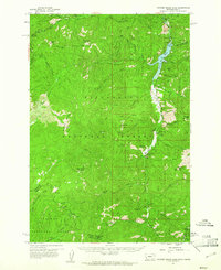
 1991 Alta1991 Print · USGSThe Bitterroot National Forest at the Montana-Idaho border shows a landscape defined by 1980s mining and wilderness management. Trace the legacy of extraction at the Lucky Joe Mine or find early sites like Alta and the Cooper Place.2 unique versions available
 - 1998 Map of Alta, 2002 Print
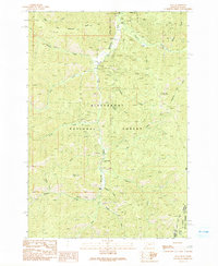
 1998 Alta2002 Print · USGSThe high Bitterroot backcountry at the Montana-Idaho border is documented here in the late 1990s as the river-cut landscape remains focused on mining and forest management. Researchers can locate the Old Alta Ranger Sta (Site) or trace legacy mining sites like the Lucky Joe Mine and Copper Queen Mine.
 - 2011 Map of Alta, 2011 Print
 2011 Alta2011 Print · USGSCovers Alta, including Ravalli County, Lemhi County, and other nearby areas
 - 2014 Map of Alta, 2014 Print
 2014 Alta2014 Print · USGSCovers Alta, including Ravalli County, Lemhi County, and other nearby areas
 - 2017 Map of Alta, 2017 Print
 2017 Alta2017 Print · USGSCovers Alta, including Ravalli County, Lemhi County, and other nearby areas
 - 2020 Map of Alta, 2020 Print
 2020 Alta2020 Print · USGSCovers Alta, including Ravalli County, Lemhi County, and other nearby areas
 - 2023 Map of Alta, 2023 Print
 2023 Alta2023 Print · USGSCovers Alta, including Ravalli County, Lemhi County, and other nearby areas
 - 2024 Map of Alta, 2024 Print
 2024 Alta2024 Print · USGSThe high mountain country near the Montana-Idaho border comes into focus in this recent survey of the Bitterroot range. Researchers can trace the drainage of the West Fork Bitterroot River and locate landmarks like Alta or Than Wilkerson Ridge.
End of results
Showing maps 1-11 of 11
Frequently asked questions
- What are the different types of historical maps available for Alta?
- What is the oldest map of Alta?
- Where can I purchase historical maps of Alta for my home or office?
- Where can I download high-res historical maps of Alta?
- Are there historical topographic maps available for Alta?
- Is there historical aerial imagery available for Alta?
- Where are historical maps of Alta sourced from?