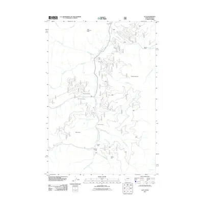
2011 Map of Alta
USGS Topo · Published 2011About this map
The West Fork Bitterroot River carves a central corridor through this Bitterroot National Forest landscape, where the small settlement of Alta serves as a gateway to a historically significant mining and timber region. This 2011 survey documents a high concentration of mining activity along the river's tributaries, including the Copper Queen Mine and the Lucky Joe Mine. The industrial footprint extends to specific claims like the Sheep Creek Columbite Mine and several section-indexed operations such as the SE SW Section 3 Mine.
Find a feature on this map
31 named features on this map. Tap any name to fly to it.
Don’t see what you’re looking for? This feature index may not catch every label — zoom into the map to look around manually.
Map Details
Editions of this 2011 Alta Map
This is the sole edition of this map. No revisions or reprints were ever made.
Other maps of this area

1956 · Elk City
USGS Topo · 1:250,000

1960 · Elk City
USGS Topo · 1:250,000

1960 · Painted Rocks Lake
USGS Topo · 1:62,500

1960 · Ulysses Mtn
USGS Topo · 1:62,500

1960 · Shoup
USGS Topo · 1:62,500

1960 · Piquett Mountain
USGS Topo · 1:62,500

1982 · Bighorn Crags
USGS Topo · 1:100,000
1991 · Piquett Mountain
USGS Topo · 1:24,000

1991 · Horse Creek Pass
USGS Topo · 1:24,000
1991 · Tincup Hill
USGS Topo · 1:24,000