1990s Maps of Gird Point, Montana
Explore 2 historic maps of Gird Point from the 1990s. These maps offer a rare glimpse into what life looked like during the 1990s — showing old roads, neighborhoods, homes, and landmarks that have changed or disappeared over time.
Whether you're researching your family's past, planning a metal detecting trip, or studying how Gird Point's landscape evolved across the 1990s, these high-resolution maps are a powerful tool for exploring the history of this region.
- Focus on a specific era: All maps on this page are from the 1990s, giving you a focused view of this time period.
- See what’s changed: Compare century-old streets, trails, and buildings to today's modern landscape using overlays and satellite layers.
- Research with precision: Use these maps for genealogy, historical research, land use analysis, or educational projects.
- View, download, or print: Maps are fully viewable online in high resolution, and can be downloaded or printed for your own records.
Start exploring Gird Point's history through authentic maps from the 1990s. This is your window into the past.
Gird Point, MT maps
(2)- 1993 Map of Philipsburg, 1994 Print
 1993 Philipsburg1994 Print · USGSThe mining and mountain country of Granite County is captured in the early nineties, showing a landscape defined by timber and mineral wealth. You can trace historical mining operations at the Black Pine Mine and Cable Mine or locate early settlements like Maxville and Southern Cross.
 - 1998 Map of Gird Point, 2002 Print
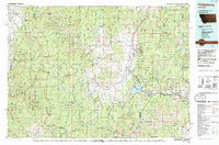
 1998 Gird Point2002 Print · USGSRavalli County in the late nineties is defined here by the managed timberlands and drainage basins of the Bitterroot National Forest. Researchers can trace forest access points and remote landmarks like Black Bear Campground, Gird Point, and the Centennial Nature Grove.
End of results
Showing maps 1-2 of 2
Frequently asked questions
- What are the different types of historical maps available for Gird Point?
- What is the oldest map of Gird Point?
- Where can I purchase historical maps of Gird Point for my home or office?
- Where can I download high-res historical maps of Gird Point?
- Are there historical topographic maps available for Gird Point?
- Is there historical aerial imagery available for Gird Point?
- Where are historical maps of Gird Point sourced from?