1990s Maps of Sula, Montana
Explore 2 historic maps of Sula from the 1990s. These maps offer a rare glimpse into what life looked like during the 1990s — showing old roads, neighborhoods, homes, and landmarks that have changed or disappeared over time.
Whether you're researching your family's past, planning a metal detecting trip, or studying how Sula's landscape evolved across the 1990s, these high-resolution maps are a powerful tool for exploring the history of this region.
- Focus on a specific era: All maps on this page are from the 1990s, giving you a focused view of this time period.
- See what’s changed: Compare century-old streets, trails, and buildings to today's modern landscape using overlays and satellite layers.
- Research with precision: Use these maps for genealogy, historical research, land use analysis, or educational projects.
- View, download, or print: Maps are fully viewable online in high resolution, and can be downloaded or printed for your own records.
Start exploring Sula's history through authentic maps from the 1990s. This is your window into the past.
Sula, MT maps
(2)- 1994 Map of Wisdom
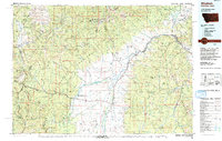 1994 Wisdom1994 Print · USGSThe high mountain valleys of Southwest Montana and East Idaho come alive in the mid-1990s as the Big Hole River meanders toward the Continental Divide. Trace the grounds of the Big Hole National Battlefield or locate remote settlements like Wisdom and Gibbonsville.2 unique versions available
 - 1998 Map of Sula, 2002 Print
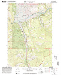 1998 Sula2002 Print · USGSThe Bitterroot mountains of western Montana are shown here in the late 1990s as the landscape transitions toward the Continental Divide. Trace local history at Sula, explore the paths of the Nez Perce Trail, and locate landmarks like the Sula Cem.
End of results
Showing maps 1-2 of 2
Top cities near Sula
Frequently asked questions
- What are the different types of historical maps available for Sula?
- What is the oldest map of Sula?
- Where can I purchase historical maps of Sula for my home or office?
- Where can I download high-res historical maps of Sula?
- Are there historical topographic maps available for Sula?
- Is there historical aerial imagery available for Sula?
- Where are historical maps of Sula sourced from?