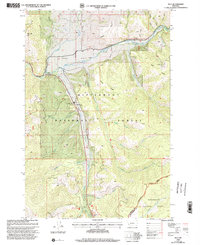
1998 Map of Sula
USGS Topo · Published 2002About this map
Ross Hole serves as a central geographical landmark on this 1990s revision, where the East Fork Bitterroot River meets several mountain drainages. The small settlement of Sula is the primary hub for this high-country area, supported by the Sula Ranger District and the Sula Cem located just north of the town center. The map documents a landscape defined by its forestry and recreation heritage, situated within the Bitterroot National Forest and extending to the Continental Divide at the boundary of Beaverhead National Forest.
Find a feature on this map
35 named features on this map. Tap any name to fly to it.
Don’t see what you’re looking for? This feature index may not catch every label — zoom into the map to look around manually.
Map Details
Editions of this 1998 Sula Map
This is the sole edition of this map. No revisions or reprints were ever made.
Other maps of this area

1955 · Dillon
USGS Topo · 1:250,000

1956 · Elk City
USGS Topo · 1:250,000

1957 · Dillon
USGS Topo · 1:250,000

1958 · Dillon
USGS Topo · 1:250,000

1960 · Elk City
USGS Topo · 1:250,000

1960 · Piquett Mountain
USGS Topo · 1:62,500

1962 · Dillon
USGS Topo · 1:250,000
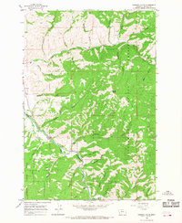
1964 · Robbins Gulch
USGS Topo · 1:24,000

1965 · Dillon
USGS Topo · 1:250,000

1965 · Medicine Hot Springs
USGS Topo · 1:24,000