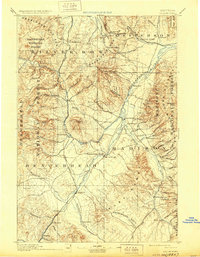
1957 Map of Dillon
USGS Topo · Published 1957About this map
Beaverhead County and the high mountain corridors of southwest Montana and eastern Idaho are captured here just as the mid-century highway system began to modernize the old ranching and mining frontiers. The Continental Divide zigzags across the sheet, separating the waters of the Salmon River from the headwaters of the Missouri system. The valley floors are anchored by Dillon, while the historic mining legacy of the region is represented by Virginia City and Silver Star. A sophisticated rail network including the Union Pacific Railroad and the Chicago Milwaukee St. Paul and Pacific Railroad follows the winding river grades, serving remote outposts like Bond Siding and Vendome Station. This 1955 compilation reflects a landscape defined by the Pioneer Mountains and Beaverhead National Forest, where irrigation and transport were dictated by the flow of the Beaverhead River and the Big Hole River.
Find a feature on this map
63 named features on this map. Tap any name to fly to it.
Don’t see what you’re looking for? This feature index may not catch every label — zoom into the map to look around manually.
Map Details
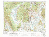
Editions of this 1957 Dillon Map
This is the sole edition of this map. No revisions or reprints were ever made.
Historical Maps of Butte Through Time
7 maps found