1965 Map of Dillon
USGS Topo · Published 1965About this map
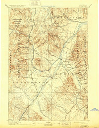
Dillon serves as a central hub in this mid-century look at southwest Montana, where the Beaverhead River and Big Hole River valleys carve through a high-altitude landscape. The map captures a critical transportation junction, showing the Union Pacific and Northern Pacific railroads connecting remote settlements like Armstead and Grant to larger centers. The Continental Divide zigzags across the territory, separating the drainages of the Jefferson River and Ruby River from the western ranges.
Find a feature on this map
144 named features on this map. Tap any name to fly to it.
Don’t see what you’re looking for? This feature index may not catch every label — zoom into the map to look around manually.
Map Details
Editions of this 1965 Dillon Map
This is the sole edition of this map. No revisions or reprints were ever made.
Historical Maps of Butte Through Time
7 maps found