1960s Maps of Shelby, Montana
Explore 2 historic maps of Shelby from the 1960s. These maps offer a rare glimpse into what life looked like during the 1960s — showing old roads, neighborhoods, homes, and landmarks that have changed or disappeared over time.
Whether you're researching your family's past, planning a metal detecting trip, or studying how Shelby's landscape evolved across the 1960s, these high-resolution maps are a powerful tool for exploring the history of this region.
- Focus on a specific era: All maps on this page are from the 1960s, giving you a focused view of this time period.
- See what’s changed: Compare century-old streets, trails, and buildings to today's modern landscape using overlays and satellite layers.
- Research with precision: Use these maps for genealogy, historical research, land use analysis, or educational projects.
- View, download, or print: Maps are fully viewable online in high resolution, and can be downloaded or printed for your own records.
Start exploring Shelby's history through authentic maps from the 1960s. This is your window into the past.
Shelby, MT maps
(2)- 1967 Map of Naismith, 1970 Print
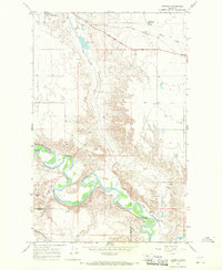 1967 Naismith1970 Print · USGSToole County's high plains meet the winding Marias River in the late 1960s, showing a landscape shaped by rail and water. Local researchers can trace the development of Shelby through its parks and Marias Fairgrounds, or locate the isolated Underdahl Ranch along the river's deep oxbows.
 - 1967 Map of Ledger NW, 1971 Print
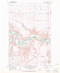 1967 Ledger NW1971 Print · USGSThe Marias River valley at the Toole and Pondera county line is captured here in the late sixties. Researchers can trace the Lewis and Clark Trail past Williamson Park and follow the rugged breaks of Schultz Coulee.
End of results
Showing maps 1-2 of 2
Frequently asked questions
- What are the different types of historical maps available for Shelby?
- What is the oldest map of Shelby?
- Where can I purchase historical maps of Shelby for my home or office?
- Where can I download high-res historical maps of Shelby?
- Are there historical topographic maps available for Shelby?
- Is there historical aerial imagery available for Shelby?
- Where are historical maps of Shelby sourced from?