1940s Maps of Rainbow Acres, Box Butte County
Explore 2 historic maps of Rainbow Acres from the 1940s. These maps offer a rare glimpse into what life looked like during the 1940s — showing old roads, neighborhoods, homes, and landmarks that have changed or disappeared over time.
Whether you're researching your family's past, planning a metal detecting trip, or studying how Rainbow Acres's landscape evolved across the 1940s, these high-resolution maps are a powerful tool for exploring the history of this region.
- Focus on a specific era: All maps on this page are from the 1940s, giving you a focused view of this time period.
- See what’s changed: Compare century-old streets, trails, and buildings to today's modern landscape using overlays and satellite layers.
- Research with precision: Use these maps for genealogy, historical research, land use analysis, or educational projects.
- View, download, or print: Maps are fully viewable online in high resolution, and can be downloaded or printed for your own records.
Start exploring Rainbow Acres's history through authentic maps from the 1940s. This is your window into the past.
Rainbow Acres, Box Butte County maps
(2)- 1947 Map of Alliance, 1967 Print
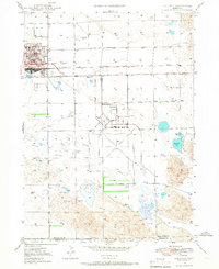 1947 Alliance1967 Print · USGSAlliance emerges as a bustling panhandle hub in the late 1940s, balancing its railroad roots with new aviation infrastructure. Researchers can locate the Courthouse, trace the Chicago Burlington and Quincy rail lines, and find rural landmarks like Greenwood Cem.2 unique versions available
 - 1948 Map of Alliance
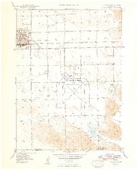 1948 Alliance1948 Print · USGSAlliance emerges as a bustling post-war rail and aviation hub in the Nebraska panhandle during the late forties. Genealogists and researchers can trace local landmarks like Greenwood Cem, East Point Sch, and the expansive Alliance Airport.2 unique versions available
End of results
Showing maps 1-2 of 2
Frequently asked questions
- What are the different types of historical maps available for Rainbow Acres?
- What is the oldest map of Rainbow Acres?
- Where can I purchase historical maps of Rainbow Acres for my home or office?
- Where can I download high-res historical maps of Rainbow Acres?
- Are there historical topographic maps available for Rainbow Acres?
- Is there historical aerial imagery available for Rainbow Acres?
- Where are historical maps of Rainbow Acres sourced from?