1960s Maps of Weeping Water, Nebraska
Explore 2 historic maps of Weeping Water from the 1960s. These maps offer a rare glimpse into what life looked like during the 1960s — showing old roads, neighborhoods, homes, and landmarks that have changed or disappeared over time.
Whether you're researching your family's past, planning a metal detecting trip, or studying how Weeping Water's landscape evolved across the 1960s, these high-resolution maps are a powerful tool for exploring the history of this region.
- Focus on a specific era: All maps on this page are from the 1960s, giving you a focused view of this time period.
- See what’s changed: Compare century-old streets, trails, and buildings to today's modern landscape using overlays and satellite layers.
- Research with precision: Use these maps for genealogy, historical research, land use analysis, or educational projects.
- View, download, or print: Maps are fully viewable online in high resolution, and can be downloaded or printed for your own records.
Start exploring Weeping Water's history through authentic maps from the 1960s. This is your window into the past.
Weeping Water, NE maps
(2)- 1966 Map of Manley, 1968 Print
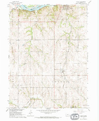 1966 Manley1968 Print · USGSCentral Cass County in the mid-1960s is defined by its strategic position between the Platte River and productive uplands. Researchers can locate family landmarks like St Patricks Cem, Dutch Sch, and the rail junction at Manley.
 - 1966 Map of Weeping Water, 1968 Print
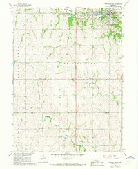 1966 Weeping Water1968 Print · USGSSoutheast Nebraska was a landscape of active limestone production and rural school districts in the mid-sixties. Trace the Missouri Pacific rail line as it passes through Weeping Water near local landmarks like Avoca Cem and Pine Sch.
End of results
Showing maps 1-2 of 2
Top cities near Weeping Water
- Bellevue historical maps
- Plattsmouth historical maps
- Gretna historical maps
- Ashland historical maps
- Syracuse historical maps
- Springfield historical maps
See more
Frequently asked questions
- What are the different types of historical maps available for Weeping Water?
- What is the oldest map of Weeping Water?
- Where can I purchase historical maps of Weeping Water for my home or office?
- Where can I download high-res historical maps of Weeping Water?
- Are there historical topographic maps available for Weeping Water?
- Is there historical aerial imagery available for Weeping Water?
- Where are historical maps of Weeping Water sourced from?