1970s Maps of Precinct 18, Nebraska
Explore 2 historic maps of Precinct 18 from the 1970s. These maps offer a rare glimpse into what life looked like during the 1970s — showing old roads, neighborhoods, homes, and landmarks that have changed or disappeared over time.
Whether you're researching your family's past, planning a metal detecting trip, or studying how Precinct 18's landscape evolved across the 1970s, these high-resolution maps are a powerful tool for exploring the history of this region.
- Focus on a specific era: All maps on this page are from the 1970s, giving you a focused view of this time period.
- See what’s changed: Compare century-old streets, trails, and buildings to today's modern landscape using overlays and satellite layers.
- Research with precision: Use these maps for genealogy, historical research, land use analysis, or educational projects.
- View, download, or print: Maps are fully viewable online in high resolution, and can be downloaded or printed for your own records.
Start exploring Precinct 18's history through authentic maps from the 1970s. This is your window into the past.
Precinct 18, NE maps
(2)- 1971 Map of Randolph North, 1973 Print
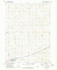 1971 Randolph North1973 Print · USGSThe northern environs of Randolph are captured in the early seventies, showing a landscape defined by the Burlington Northern railroad. Researchers can trace the Old RR Grade and locate family burial sites at St Frances Cem.
 - 1971 Map of Magnet, 1973 Print
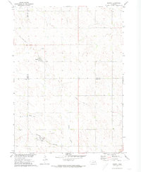 1971 Magnet1973 Print · USGSThe rural borderlands of Cedar, Knox, and Pierce Counties are captured here in the early 1970s. Genealogists and historians can trace the Burlington Northern line through McLean, locate the Magnet Cem, and follow an Old Railroad Grade.
End of results
Showing maps 1-2 of 2
Top cities near Precinct 18
- Hartington historical maps
- Bloomfield historical maps
- Randolph historical maps
- Osmond historical maps
- Wausa historical maps
- Coleridge historical maps
See more
Top neighborhoods of Precinct 18
Frequently asked questions
- What are the different types of historical maps available for Precinct 18?
- What is the oldest map of Precinct 18?
- Where can I purchase historical maps of Precinct 18 for my home or office?
- Where can I download high-res historical maps of Precinct 18?
- Are there historical topographic maps available for Precinct 18?
- Is there historical aerial imagery available for Precinct 18?
- Where are historical maps of Precinct 18 sourced from?