1970s Maps of Sidney, Nebraska
Explore 2 historic maps of Sidney from the 1970s. These maps offer a rare glimpse into what life looked like during the 1970s — showing old roads, neighborhoods, homes, and landmarks that have changed or disappeared over time.
Whether you're researching your family's past, planning a metal detecting trip, or studying how Sidney's landscape evolved across the 1970s, these high-resolution maps are a powerful tool for exploring the history of this region.
- Focus on a specific era: All maps on this page are from the 1970s, giving you a focused view of this time period.
- See what’s changed: Compare century-old streets, trails, and buildings to today's modern landscape using overlays and satellite layers.
- Research with precision: Use these maps for genealogy, historical research, land use analysis, or educational projects.
- View, download, or print: Maps are fully viewable online in high resolution, and can be downloaded or printed for your own records.
Start exploring Sidney's history through authentic maps from the 1970s. This is your window into the past.
Sidney, NE maps
(2)- 1972 Map of Sidney Muni. Airport, 1976 Print
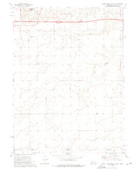 1972 Sidney Muni. Airport1976 Print · USGSThe Nebraska-Colorado high plains are captured in the early seventies as Interstate 80 and modern aviation reshape the landscape near Sidney. Researchers can locate the Grand Prairie Cem, Trinity Sch, and a mid-century Drive-in Theater.
 - 1972 Map of Sidney, 1976 Print
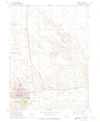 1972 Sidney1976 Print · USGSSidney and its surrounding high plains are captured here in the early seventies, showcasing a landscape defined by heavy rail and energy production. Researchers can locate the Abandoned Ammunition Depot, several local schools like School No 77, and the prominent OIL FIELD.
End of results
Showing maps 1-2 of 2
Top cities near Sidney
Top neighborhoods of Sidney
Frequently asked questions
- What are the different types of historical maps available for Sidney?
- What is the oldest map of Sidney?
- Where can I purchase historical maps of Sidney for my home or office?
- Where can I download high-res historical maps of Sidney?
- Are there historical topographic maps available for Sidney?
- Is there historical aerial imagery available for Sidney?
- Where are historical maps of Sidney sourced from?