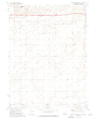
1972 Map of Sidney Muni. Airport
USGS Topo · Published 1976About this map
High plains terrain along the Nebraska-Colorado border dominates this 1972 survey, centered on the infrastructure of Sidney Municipal Airport. The landscape is a study in rural utility, where Interstate 80 cuts a sharp horizontal line across the northern townships, passing a designated Rest Area. Near the city of Sidney, local entertainment and communication are represented by the Drive-in Theater and multiple radio installations, including a Radio Facility and Radio Tower.
Find a feature on this map
17 named features on this map. Tap any name to fly to it.
Don’t see what you’re looking for? This feature index may not catch every label — zoom into the map to look around manually.
Map Details
Editions of this 1972 Sidney Muni. Airport Map
This is the sole edition of this map. No revisions or reprints were ever made.
Other maps of this area

1899 · Sidney
USGS Topo · 1:125,000

1953 · Peetz
USGS Topo · 1:24,000

1953 · Twin Buttes
USGS Topo · 1:24,000

1953 · Haystack Butte
USGS Topo · 1:24,000

1954 · Sterling
USGS Topo · 1:250,000

1954 · Scottsbluff
USGS Topo · 1:250,000

1958 · Scottsbluff
USGS Topo · 1:250,000

1958 · Sterling
USGS Topo · 1:250,000
1971 · Twin Buttes
USGS Topo · 1:24,000

1972 · Lorenzo
USGS Topo · 1:24,000