
1953 Map of Haystack Butte
USGS Topo · Published 1954About this map
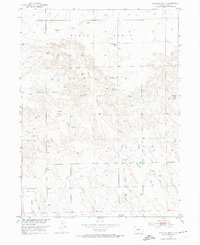
Peetz Table dominates the northern half of this mid-century Logan County landscape, representing a high plateau punctuated by numerous Windmills essential for upland ranching and agriculture. The terrain transitions from these flat plains into a network of complex erosional features to the south, where Spring Canyon and its tributaries like Wild Horse Draw carve through the earth. One of the few early educational landmarks, the Lauderback School, is situated on the tableland near the Peetz Television Relay Station, highlighting the sparse but organized settlement pattern of the early 1950s.
Find a feature on this map
19 named features on this map. Tap any name to fly to it.
Don’t see what you’re looking for? This feature index may not catch every label — zoom into the map to look around manually.
Map Details
Editions of this 1953 Haystack Butte Map
2 editions found
Other maps of this area

1899 · Sidney
USGS Topo · 1:125,000

1951 · Iliff
USGS Topo · 1:24,000

1953 · Peetz
USGS Topo · 1:24,000

1953 · Crook
USGS Topo · 1:24,000

1953 · Twin Buttes
USGS Topo · 1:24,000

1953 · Proctor
USGS Topo · 1:24,000

1954 · Sterling
USGS Topo · 1:250,000

1954 · Scottsbluff
USGS Topo · 1:250,000

1958 · Scottsbluff
USGS Topo · 1:250,000

1958 · Sterling
USGS Topo · 1:250,000