1970s Maps of Cozad, Nebraska
Explore 4 historic maps of Cozad from the 1970s. These maps offer a rare glimpse into what life looked like during the 1970s — showing old roads, neighborhoods, homes, and landmarks that have changed or disappeared over time.
Whether you're researching your family's past, planning a metal detecting trip, or studying how Cozad's landscape evolved across the 1970s, these high-resolution maps are a powerful tool for exploring the history of this region.
- Focus on a specific era: All maps on this page are from the 1970s, giving you a focused view of this time period.
- See what’s changed: Compare century-old streets, trails, and buildings to today's modern landscape using overlays and satellite layers.
- Research with precision: Use these maps for genealogy, historical research, land use analysis, or educational projects.
- View, download, or print: Maps are fully viewable online in high resolution, and can be downloaded or printed for your own records.
Start exploring Cozad's history through authentic maps from the 1970s. This is your window into the past.
Cozad, NE maps
(4)- 1970 Map of Willow Island, 1973 Print
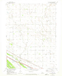 1970 Willow Island1973 Print · USGSCentral Nebraska's Platte River valley is captured in the early seventies, showing a landscape defined by irrigation and rail. Trace the footprints of rural life at Willow Island, Center Star Sch, and the Willow Island Cem.
 - 1970 Map of Gothenburg SE, 1973 Print
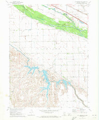 1970 Gothenburg SE1973 Print · USGSThe Platte River valley in the early seventies shows a landscape defined by intensive irrigation and the Union Pacific railroad. Trace rural landmarks like Decker Sch, Pleasant View Cem, and the recreational camps around Central Midway Lake.
 - 1971 Map of Cozad, 1973 Print
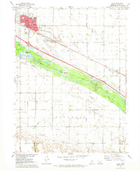 1971 Cozad1973 Print · USGSCozad and the Platte River valley are captured in the early 1970s, showing a landscape defined by irrigation and historic trails. Researchers can locate numerous numbered rural schools and trace the Emigrant Trail alongside the Cozad Canal.
 - 1979 Map of Gothenburg
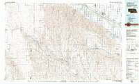 1979 Gothenburg1979 Print · USGSThe Nebraska Loess Hills and the Platte River valley are captured here in the late seventies, showing a landscape defined by irrigation and rail. Researchers can trace the Union Pacific line through Gothenburg, locate family sites near Eustis, or explore the canyon country around Stockville.
End of results
Showing maps 1-4 of 4
Top cities near Cozad
Top neighborhoods of Cozad
Frequently asked questions
- What are the different types of historical maps available for Cozad?
- What is the oldest map of Cozad?
- Where can I purchase historical maps of Cozad for my home or office?
- Where can I download high-res historical maps of Cozad?
- Are there historical topographic maps available for Cozad?
- Is there historical aerial imagery available for Cozad?
- Where are historical maps of Cozad sourced from?