1960s Maps of Douglas County, Nebraska
Explore 8 historic maps of Douglas County from the 1960s. These maps offer a rare glimpse into what life looked like during the 1960s — showing old roads, neighborhoods, homes, and landmarks that have changed or disappeared over time.
Whether you're researching your family's past, planning a metal detecting trip, or studying how Douglas County's landscape evolved across the 1960s, these high-resolution maps are a powerful tool for exploring the history of this region.
- Focus on a specific era: All maps on this page are from the 1960s, giving you a focused view of this time period.
- See what’s changed: Compare century-old streets, trails, and buildings to today's modern landscape using overlays and satellite layers.
- Research with precision: Use these maps for genealogy, historical research, land use analysis, or educational projects.
- View, download, or print: Maps are fully viewable online in high resolution, and can be downloaded or printed for your own records.
Start exploring Douglas County's history through authentic maps from the 1960s. This is your window into the past.
Douglas County, NE maps
(8)- 1968 Map of Valley, 1970 Print
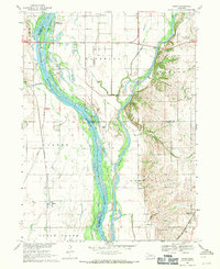
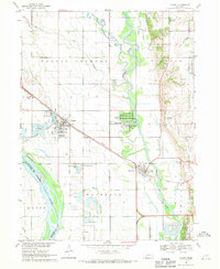 1968 Valley1970 Print · USGSThe confluence of the Elkhorn and Platte rivers in the late 1960s highlights a period of significant growth for Douglas County. Researchers can trace the development of Valley and Waterloo alongside landmarks like St John Seminary and the Elk City Cem.3 unique versions available
 - 1968 Map of Leshara, 1971 Print
 1968 Leshara1971 Print · USGSSaunders County near the Platte River valley in the late sixties shows a landscape defined by the railroad and the river. Trace family roots at Pleasant View Cemetery, locate old country schoolhouses like Mercer School, and follow the steel of the Union Pacific.2 unique versions available
 - 1968 Map of Fremont East, 1971 Print
 1968 Fremont East1971 Print · USGSThe rail and river networks of eastern Nebraska converged here in the late sixties, showing a period of significant civic and industrial growth. Researchers can trace family roots through numerous neighborhood landmarks like St Patricks Sch, Midland College, and Ruwe Park.3 unique versions available
 - 1968 Map of Kennard, 1971 Print
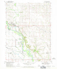
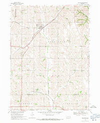 1968 Kennard1971 Print · USGSEastern Nebraska farming communities and rail corridors are frozen in time here just before the 1970s. Local historians can trace the Chicago and North Western tracks and locate rural anchors like Sunny Side Sch and the German Cem.
 - 1968 Map of Wann, 1971 Print
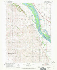
 1968 Wann1971 Print · USGSThe confluence of the Platte and Elkhorn rivers in the late 1960s reveals a landscape shaped by water and rail. Genealogists and local historians can locate Holy Sepulcher Cem, the small settlement of Venice, and Two Rivers Ch near the banks of the Platte River.2 unique versions available
 - 1968 Map of Arlington, 1971 Print
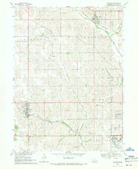
 1968 Arlington1971 Print · USGSThe village of Arlington and the fertile Elkhorn River valley are captured here in the late sixties as the local rail and water networks shaped the region. Genealogists can locate family sites near Arlington Cem, School No 43, and along the banks of Rawhide Creek.2 unique versions available
 - 1968 Map of Fort Calhoun, 1971 Print
 1968 Fort Calhoun1971 Print · USGSThe Missouri River bluffs at Fort Calhoun are captured in the late sixties, showing a landscape of rural schools and riverbottom conservation. Genealogists and local historians can locate the Pioneer Memorial Cem, Wranck Sch, and the Bil-Lo Landing Strip.2 unique versions available
 - 1968 Map of Elkhorn, 1971 Print
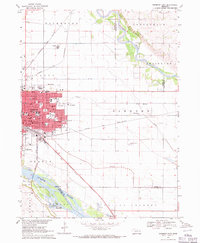
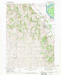
 1968 Elkhorn1971 Print · USGSWest of Omaha in the late sixties, this survey captures the transition from historic railroad towns to burgeoning residential communities. Genealogists and local researchers can trace the sites of St Patricks Seminary, Flower Hill Cem, and the unique institutional grounds of Boys Town.4 unique versions available
End of results
Showing maps 1-8 of 8
Top cities of Douglas County
- Omaha historical maps
- Ralston historical maps
- Valley historical maps
- Bennington historical maps
- Waterloo historical maps
Frequently asked questions
- What are the different types of historical maps available for Douglas County?
- What is the oldest map of Douglas County?
- Where can I purchase historical maps of Douglas County for my home or office?
- Where can I download high-res historical maps of Douglas County?
- Are there historical topographic maps available for Douglas County?
- Is there historical aerial imagery available for Douglas County?
- Where are historical maps of Douglas County sourced from?