1970s Maps of Gage County, Nebraska
Explore 8 historic maps of Gage County from the 1970s. These maps offer a rare glimpse into what life looked like during the 1970s — showing old roads, neighborhoods, homes, and landmarks that have changed or disappeared over time.
Whether you're researching your family's past, planning a metal detecting trip, or studying how Gage County's landscape evolved across the 1970s, these high-resolution maps are a powerful tool for exploring the history of this region.
- Focus on a specific era: All maps on this page are from the 1970s, giving you a focused view of this time period.
- See what’s changed: Compare century-old streets, trails, and buildings to today's modern landscape using overlays and satellite layers.
- Research with precision: Use these maps for genealogy, historical research, land use analysis, or educational projects.
- View, download, or print: Maps are fully viewable online in high resolution, and can be downloaded or printed for your own records.
Start exploring Gage County's history through authentic maps from the 1970s. This is your window into the past.
Gage County, NE maps
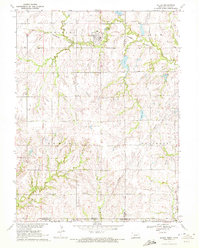
(8)- 1970 Map of Diller NE, 1971 Print
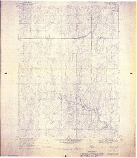 1970 Diller NE1971 Print · USGSGage County agriculture and rail life are at the forefront of this 1970s survey. Genealogists and historians can trace the Chicago Rock Island and Pacific tracks through Ellis, finding local landmarks like Ellis Cem and Pleasant Hill Cem.2 unique versions available
 - 1970 Map of Wymore, 1972 Print
 1970 Wymore1972 Print · USGSNear the Nebraska-Kansas border in the early seventies, the landscape around Wymore remains defined by the Big Blue River and its rail junctions. Researchers can trace the Old Indian Treaty Boundary and locate family plots at Wymore Cem or St Johns Cem.
 - 1970 Map of Harbine, 1972 Print
 1970 Harbine1972 Print · USGSHarbine and Ellis sit at the Jefferson and Gage County line in the early 1970s as the railroad still defines the rural landscape. Genealogists can trace family names through the Harbine Cemetery, Hope Church, and rural Zion School.
 - 1970 Map of Barneston, 1972 Print
 1970 Barneston1972 Print · USGSThe Nebraska-Kansas borderlands come into focus in the early 1970s as the river economy meets the rail lines. Genealogists and historians can trace the Indian Treaty Boundary, the village of Barneston, and the Liberty Cemetery along the Big Blue River.
 - 1970 Map of Diller, 1972 Print
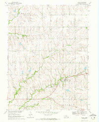
 1970 Diller1972 Print · USGSThe Nebraska-Kansas border comes into focus in the early 1970s, centered on the railroad town of Diller. Researchers can trace the rural landscape across state lines to find the Evangelical Ch, the Pleasant View Sch, and the rail siding at Lanham.
 - 1970 Map of Odell, 1972 Print
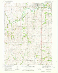
 1970 Odell1972 Print · USGSOdell and the Nebraska-Kansas border lands are captured here in the early 1970s as the rail and river networks shaped local commerce. Researchers can locate specific family heritage sites like the Czech National Cem and the Old Indian Treaty Boundary.
 - 1970 Map of Filley, 1972 Print
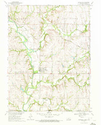
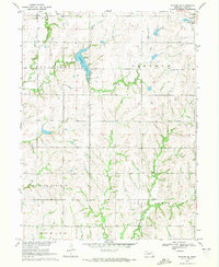
 1970 Filley1972 Print · USGSThe prairie landscape around Filley is captured here as it appeared in the late sixties, showing the vital agricultural and drainage patterns of eastern Gage County. Genealogists and local historians can locate Zion Cem, Filley Cem, and the path of the Old Railroad Grade.2 unique versions available
 - 1970 Map of Wymore NE, 1972 Print
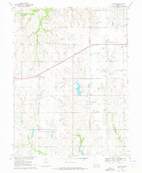
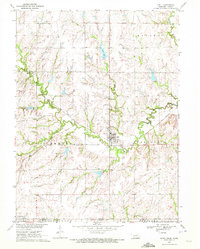
 1970 Wymore NE1972 Print · USGSGage County's agricultural and recreational landscape comes into focus during the early 1970s. Researchers can trace family history through Stark Cem, locate the Old Railroad Grade, and explore the shoreline of Rockford Lake.
End of results
Showing maps 1-8 of 8
Top cities of Gage County
- Beatrice historical maps
- Wymore historical maps
- Cortland historical maps
- Adams historical maps
- Rockford historical maps
- Odell historical maps
See more
Frequently asked questions
- What are the different types of historical maps available for Gage County?
- What is the oldest map of Gage County?
- Where can I purchase historical maps of Gage County for my home or office?
- Where can I download high-res historical maps of Gage County?
- Are there historical topographic maps available for Gage County?
- Is there historical aerial imagery available for Gage County?
- Where are historical maps of Gage County sourced from?