1960s Maps of Holmesville, Nebraska
Explore 1 historic maps of Holmesville from the 1960s. These maps offer a rare glimpse into what life looked like during the 1960s — showing old roads, neighborhoods, homes, and landmarks that have changed or disappeared over time.
Whether you're researching your family's past, planning a metal detecting trip, or studying how Holmesville's landscape evolved across the 1960s, these high-resolution maps are a powerful tool for exploring the history of this region.
- Focus on a specific era: All maps on this page are from the 1960s, giving you a focused view of this time period.
- See what’s changed: Compare century-old streets, trails, and buildings to today's modern landscape using overlays and satellite layers.
- Research with precision: Use these maps for genealogy, historical research, land use analysis, or educational projects.
- View, download, or print: Maps are fully viewable online in high resolution, and can be downloaded or printed for your own records.
Start exploring Holmesville's history through authentic maps from the 1960s. This is your window into the past.
Holmesville, NE maps
(1)- 1964 Map of Blue Springs, 1965 Print
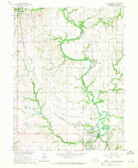 1964 Blue Springs1965 Print · USGSGage County in the mid-1960s reveals a landscape where the Big Blue River snakes between industrial hubs and rural townships. Researchers can trace historic rail corridors and local heritage sites like St Marys Cemetery, Maple Grove School, and the riverfront operations in Holmesville.
End of results
Showing maps 1-1 of 1
Top cities near Holmesville
- Beatrice historical maps
- Wymore historical maps
- Rockford historical maps
- Odell historical maps
- Blue Springs historical maps
- Pickrell historical maps
See more
Frequently asked questions
- What are the different types of historical maps available for Holmesville?
- What is the oldest map of Holmesville?
- Where can I purchase historical maps of Holmesville for my home or office?
- Where can I download high-res historical maps of Holmesville?
- Are there historical topographic maps available for Holmesville?
- Is there historical aerial imagery available for Holmesville?
- Where are historical maps of Holmesville sourced from?