1900s (20th Century) Maps of Dyer, Nebraska
Explore 7 historic maps of Dyer from the 1900s (20th Century). These maps offer a rare glimpse into what life looked like during the 1900s — showing old roads, neighborhoods, homes, and landmarks that have changed or disappeared over time.
Whether you're researching your family's past, planning a metal detecting trip, or studying how Dyer's landscape evolved across the 1900s, these high-resolution maps are a powerful tool for exploring the history of this region.
- Focus on a specific era: All maps on this page are from the 1900s, giving you a focused view of this time period.
- See what’s changed: Compare century-old streets, trails, and buildings to today's modern landscape using overlays and satellite layers.
- Research with precision: Use these maps for genealogy, historical research, land use analysis, or educational projects.
- View, download, or print: Maps are fully viewable online in high resolution, and can be downloaded or printed for your own records.
Start exploring Dyer's history through authentic maps from the 1900s. This is your window into the past.
Dyer, NE maps
(7)- 1949 Map of Jamison SW, 1976 Print
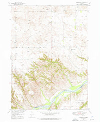 1949 Jamison SW1976 Print · USGSThe Niobrara River breaks in north-central Nebraska are captured here in the late 1940s as rural life centered on the local schoolhouse. Genealogists and local historians can trace ranching roots through landmarks like Bothwell Sch, Holton Sch, and Big Anne Spring.
 - 1951 Map of Jamison SW
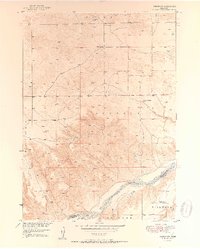 1951 Jamison SW1951 Print · USGSThe Niobrara River breaks and prairie of north-central Nebraska are captured here in the late 1940s. Genealogists can locate rural landmarks like Bothwell Sch, Holton Sch, and the riverside settlement of Dyer.2 unique versions available
 - 1955 Map of O'Neill, 1974 Print
 1955 O'Neill1974 Print · USGSNorth-central Nebraska in the 1950s reveals a vast cattle-ranching landscape transitioning from the Missouri River breaks to the iconic Sand Hills. Researchers can trace the path of the Chicago and North Western rail line and locate rural landmarks like the Dustin Post Office and St Johns Lake Ch.2 unique versions available
 - 1959 Map of O'Neill
 1959 O'Neill1959 Print · USGSNorth-central Nebraska in the late fifties is defined by the vast Sand Hills and the vital Chicago and North Western rail line. Genealogists and researchers can trace family roots through settlements like Atkinson, Bassett, and Stuart or follow the waters of the Niobrara River.2 unique versions available
 - 1969 Map of O'Neill
 1969 O'Neill1969 Print · USGSCentral Nebraska in the mid-fifties is defined here by the expansive Sand Hills and the winding Niobrara River. Trace the Chicago and North Western rail line through cattle towns like O'Neill and Ainsworth.
 - 1985 Map of Ainsworth
 1985 Ainsworth1985 Print · USGSThe Nebraska-South Dakota borderlands come into focus in the mid-1980s, documenting a landscape of river breaks and remote ranching hubs. Genealogists can trace the rural layout of Ainsworth, Bassett, and Springview or follow the Chicago and North Western rail line.2 unique versions available
 - 1989 Map of O'Neill
 1989 O'Neill1989 Print · USGSThe Nebraska-South Dakota borderlands are captured here in the late eighties, documenting the ranching and rail infrastructure of the High Plains. Genealogists and collectors can trace historic prairie towns like Monowi, Pishelville, and Santee along the Niobrara River.
End of results
Showing maps 1-7 of 7
Top cities near Dyer
Frequently asked questions
- What are the different types of historical maps available for Dyer?
- What is the oldest map of Dyer?
- Where can I purchase historical maps of Dyer for my home or office?
- Where can I download high-res historical maps of Dyer?
- Are there historical topographic maps available for Dyer?
- Is there historical aerial imagery available for Dyer?
- Where are historical maps of Dyer sourced from?