1970s Maps of Bloomfield, Nebraska
Explore 2 historic maps of Bloomfield from the 1970s. These maps offer a rare glimpse into what life looked like during the 1970s — showing old roads, neighborhoods, homes, and landmarks that have changed or disappeared over time.
Whether you're researching your family's past, planning a metal detecting trip, or studying how Bloomfield's landscape evolved across the 1970s, these high-resolution maps are a powerful tool for exploring the history of this region.
- Focus on a specific era: All maps on this page are from the 1970s, giving you a focused view of this time period.
- See what’s changed: Compare century-old streets, trails, and buildings to today's modern landscape using overlays and satellite layers.
- Research with precision: Use these maps for genealogy, historical research, land use analysis, or educational projects.
- View, download, or print: Maps are fully viewable online in high resolution, and can be downloaded or printed for your own records.
Start exploring Bloomfield's history through authentic maps from the 1970s. This is your window into the past.
Bloomfield, NE maps
(2)- 1974 Map of Bloomfield, 1978 Print
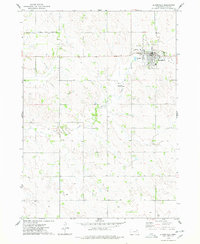 1974 Bloomfield1978 Print · USGSKnox County agricultural life and civic boundaries are preserved here in the mid-1970s. Researchers can trace the Old RR Gr near Bloomfield or locate the northern boundary of the Santee Indian Reservation.
 - 1977 Map of Bloomfield, 1979 Print
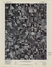 1977 Bloomfield1979 Print · USGSBloomfield and the surrounding Knox County plains are captured in this late-seventies aerial survey during a period of agricultural transition. Researchers can trace the development of the Bloomfield town site and the natural course of Bazile Creek.
End of results
Showing maps 1-2 of 2
Top cities near Bloomfield
- Crofton historical maps
- Wausa historical maps
- Center historical maps
- Magnet historical maps
- McLean historical maps
Top neighborhoods of Bloomfield
Frequently asked questions
- What are the different types of historical maps available for Bloomfield?
- What is the oldest map of Bloomfield?
- Where can I purchase historical maps of Bloomfield for my home or office?
- Where can I download high-res historical maps of Bloomfield?
- Are there historical topographic maps available for Bloomfield?
- Is there historical aerial imagery available for Bloomfield?
- Where are historical maps of Bloomfield sourced from?