1890s Maps of Lancaster County, Nebraska
Explore 4 historic maps of Lancaster County from the 1890s. These maps offer a rare glimpse into what life looked like during the 1890s — showing old roads, neighborhoods, homes, and landmarks that have changed or disappeared over time.
Whether you're researching your family's past, planning a metal detecting trip, or studying how Lancaster County's landscape evolved across the 1890s, these high-resolution maps are a powerful tool for exploring the history of this region.
- Focus on a specific era: All maps on this page are from the 1890s, giving you a focused view of this time period.
- See what’s changed: Compare century-old streets, trails, and buildings to today's modern landscape using overlays and satellite layers.
- Research with precision: Use these maps for genealogy, historical research, land use analysis, or educational projects.
- View, download, or print: Maps are fully viewable online in high resolution, and can be downloaded or printed for your own records.
Start exploring Lancaster County's history through authentic maps from the 1890s. This is your window into the past.
Lancaster County, NE maps
(4)- 1893 Map of Fremont, 1960 Print
 1893 Fremont1960 Print · USGSEastern Nebraska was a nexus of river navigation and rail expansion in the 1890s as the prairie gave way to organized township grids. Genealogists and historians can trace early settlements and transportation corridors through Fort Calhoun, the growth of Fremont, and the junctions of the Union Pacific R.R..
 - 1896 Map of Fremont
 1896 Fremont1896 Print · USGSThe rail-driven growth of eastern Nebraska is captured here in the late nineteenth century as steam power connected the prairie. Researchers can trace ancestral roots through dozens of established settlements like Fontanelle, Gretna, and Papillion, or follow the historic routes of the Union Pacific R.R. and the Elkhorn River.5 unique versions available
 - 1897 Map of Lincoln
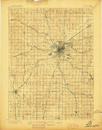 1897 Lincoln1897 Print · USGSLate-Victorian Nebraska comes into focus here as a bustling hub of steam and steel, centered on the capital. You can trace the early layouts of University Place and Bethany or locate rural landmarks like the Asylum, Lincoln Salt Lake, and the rail stop at Prairie Home.4 unique versions available
 - 1899 Map of Wahoo
 1899 Wahoo1899 Print · USGSSaunders County and its neighbors thrive as a booming rail hub in the 1890s, where the Platte River meets a dense web of iron tracks. Trace the early development of prairie towns like Wahoo, Valparaiso, and the Bohemian settlement at Prague.3 unique versions available
End of results
Showing maps 1-4 of 4
Top cities of Lancaster County
- Lincoln historical maps
- Waverly historical maps
- Hickman historical maps
- Bennet historical maps
- Firth historical maps
- Hallam historical maps
See more
Frequently asked questions
- What are the different types of historical maps available for Lancaster County?
- What is the oldest map of Lancaster County?
- Where can I purchase historical maps of Lancaster County for my home or office?
- Where can I download high-res historical maps of Lancaster County?
- Are there historical topographic maps available for Lancaster County?
- Is there historical aerial imagery available for Lancaster County?
- Where are historical maps of Lancaster County sourced from?