1960s Maps of Family Acres, Lincoln
Explore 4 historic maps of Family Acres from the 1960s. These maps offer a rare glimpse into what life looked like during the 1960s — showing old roads, neighborhoods, homes, and landmarks that have changed or disappeared over time.
Whether you're researching your family's past, planning a metal detecting trip, or studying how Family Acres's landscape evolved across the 1960s, these high-resolution maps are a powerful tool for exploring the history of this region.
- Focus on a specific era: All maps on this page are from the 1960s, giving you a focused view of this time period.
- See what’s changed: Compare century-old streets, trails, and buildings to today's modern landscape using overlays and satellite layers.
- Research with precision: Use these maps for genealogy, historical research, land use analysis, or educational projects.
- View, download, or print: Maps are fully viewable online in high resolution, and can be downloaded or printed for your own records.
Start exploring Family Acres's history through authentic maps from the 1960s. This is your window into the past.
Family Acres, Lincoln maps
(4)- 1964 Map of Roca, 1965 Print
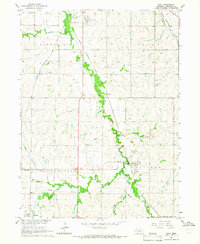 1964 Roca1965 Print · USGSSoutheast of Lincoln in the mid-1960s, a dense network of five major railroads converges along the Salt Creek valley. Researchers can trace the heritage of local industry and education through Quarries near Roca and rural schoolhouses like Hedge Hill Sch.2 unique versions available
 - 1964 Map of Walton, 1966 Print
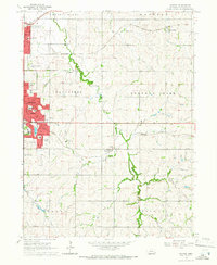 1964 Walton1966 Print · USGSThe eastern outskirts of Lincoln and the surrounding Lancaster County townships appear here during a period of mid-century suburban growth. Genealogists and local historians can trace the development of Bethany and Havelock, or locate rural landmarks like Schultz Cem and the community of Walton.3 unique versions available
 - 1964 Map of Lincoln, 1966 Print
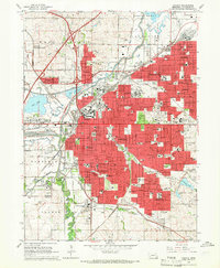 1964 Lincoln1966 Print · USGSMid-century Lincoln is captured here during a time of major institutional and military expansion. Genealogists and historians can trace the development of neighborhoods like University Place and Belmont or locate historic sites such as the State Penitentiary and Pioneers Park.3 unique versions available
 - 1966 Map of Bennet, 1967 Print
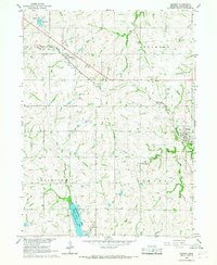 1966 Bennet1967 Print · USGSSoutheast of Lincoln in the mid-sixties, this landscape showcases a rural rail-and-river economy centered on the Chicago Burlington and Quincy line. Researchers can trace family plots at Cheney Cem or explore the development of Wagon Train Lake.2 unique versions available
End of results
Showing maps 1-4 of 4
Frequently asked questions
- What are the different types of historical maps available for Family Acres?
- What is the oldest map of Family Acres?
- Where can I purchase historical maps of Family Acres for my home or office?
- Where can I download high-res historical maps of Family Acres?
- Are there historical topographic maps available for Family Acres?
- Is there historical aerial imagery available for Family Acres?
- Where are historical maps of Family Acres sourced from?