1960s Maps of Stromsburg, Nebraska
Explore 2 historic maps of Stromsburg from the 1960s. These maps offer a rare glimpse into what life looked like during the 1960s — showing old roads, neighborhoods, homes, and landmarks that have changed or disappeared over time.
Whether you're researching your family's past, planning a metal detecting trip, or studying how Stromsburg's landscape evolved across the 1960s, these high-resolution maps are a powerful tool for exploring the history of this region.
- Focus on a specific era: All maps on this page are from the 1960s, giving you a focused view of this time period.
- See what’s changed: Compare century-old streets, trails, and buildings to today's modern landscape using overlays and satellite layers.
- Research with precision: Use these maps for genealogy, historical research, land use analysis, or educational projects.
- View, download, or print: Maps are fully viewable online in high resolution, and can be downloaded or printed for your own records.
Start exploring Stromsburg's history through authentic maps from the 1960s. This is your window into the past.
Stromsburg, NE maps
(2)- 1965 Map of Stromsburg, 1966 Print
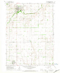 1965 Stromsburg1966 Print · USGSMid-century Nebraska life unfolds across the Polk and York county lines, where the Swedish heritage hub of Stromsburg anchors a landscape of river-fed agriculture. Trace the path of the Union Pacific and an Old Railroad Grade near Benedict.
 - 1965 Map of Osceola, 1966 Print
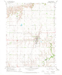 1965 Osceola1966 Print · USGSIn the mid-sixties, this Nebraska farming community was defined by the intersection of the Union Pacific and the Big Blue River. Researchers can trace the layout of Osceola, including the County Fairground, the Stromsburg Airport, and local cemeteries.2 unique versions available
End of results
Showing maps 1-2 of 2
Top cities near Stromsburg
- York historical maps
- Osceola historical maps
- Shelby historical maps
- Silver Creek historical maps
- Polk historical maps
- Benedict historical maps
See more
Frequently asked questions
- What are the different types of historical maps available for Stromsburg?
- What is the oldest map of Stromsburg?
- Where can I purchase historical maps of Stromsburg for my home or office?
- Where can I download high-res historical maps of Stromsburg?
- Are there historical topographic maps available for Stromsburg?
- Is there historical aerial imagery available for Stromsburg?
- Where are historical maps of Stromsburg sourced from?